
Castro Marim topographic map
Interactive map
Click on the map to display elevation.
About this map
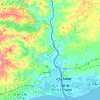
Name: Castro Marim topographic map, elevation, terrain.
Location: Castro Marim, Faro, Portugal (37.16685 -7.63707 37.39457 -7.41257)
Average elevation: 70 m
Minimum elevation: -2 m
Maximum elevation: 285 m
Other topographic maps
Click on a map to view its topography, its elevation and its terrain.
Torre
Portugal > Faro > São Bartolomeu de Messines
Torre, São Bartolomeu de Messines, Silves, Faro, 8375-022, Portugal
Average elevation: 126 m