
Kampung Bok Bak topographic map
Interactive map
Click on the map to display elevation.
About this map
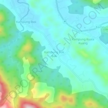
Name: Kampung Bok Bak topographic map, elevation, terrain.
Location: Kampung Bok Bak, Baling, Kedah, Malaysia (5.53240 100.85819 5.57240 100.89819)
Average elevation: 157 m
Minimum elevation: 57 m
Maximum elevation: 505 m
Other topographic maps
Click on a map to view its topography, its elevation and its terrain.
Local Authority Kulim Hi-Tech Industrial Park
Local Authority Kulim Hi-Tech Industrial Park, Kulim, Kedah, 09090, Malaysia
Average elevation: 57 m
Sungai Petani
Malaysia > Kedah > Sungai Petani
Sungai Petani, Kuala Muda, Kedah, 08000, Malaysia
Average elevation: 45 m
Kampung Tok Weng
Malaysia > Kedah > Baling > Kampung Tok Weng
Kampung Tok Weng, Baling, Kedah, 09100, Malaysia
Average elevation: 115 m
Alor Setar
Malaysia > Kedah > Alor Setar
Alor Setar, Kota Setar, Kedah, 05672, Malaysia
Average elevation: 9 m
Kuala Nerang
Malaysia > Kedah > Kuala Nerang
Kuala Nerang, Padang Terap, Kedah, 06300, Malaysia
Average elevation: 32 m
Pulau Jong
Malaysia > Kedah > Pantai Tanjung Rhu
Pulau Jong, Pantai Tanjung Rhu, Kedah, Malaysia
Average elevation: 28 m