
Everglades National Park topographic map
Interactive map
Click on the map to display elevation.
About this map
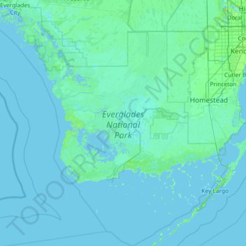
Name: Everglades National Park topographic map, elevation, terrain.
Location: Everglades National Park, Florida, 34138, United States (24.85099 -81.52053 25.89151 -80.38869)
Average elevation: 2 m
Minimum elevation: -2 m
Maximum elevation: 42 m
Everglades National Park covers 1,508,976 acres (2,357.8 sq mi; 6,106.6 km2), throughout Dade, Monroe, and Collier counties in Florida, at the southern tip of the Atlantic coastal plain. The elevation typically ranges from 0 to 8 feet (2.4 m) above sea level, but a Calusa-built shell mound on the Gulf Coast rises 20 feet (6.1 m) above sea level.
Other topographic maps
Click on a map to view its topography, its elevation and its terrain.
Milton
United States > Florida > Santa Rosa County
Milton, Santa Rosa County, Florida, 32572, United States
Average elevation: 15 m
Bradford County
Bradford County, Florida, United States
Average elevation: 45 m
Panama City
United States > Florida > Bay County
Panama City, Bay County, Florida, United States
Average elevation: 5 m
Flynn Park
United States > Florida > Duval County > Jacksonville
Flynn Park, Mandarin, Jacksonville, Duval County, Florida, United States
Average elevation: 8 m
Niceville
United States > Florida > Okaloosa County
Niceville, Okaloosa County, Florida, United States
Average elevation: 12 m
Hernando County
Hernando County, Florida, United States
Average elevation: 18 m
Miami
United States > Florida > Miami-Dade County
Miami, Miami-Dade County, Florida, 33131, United States
Average elevation: 4 m
Old Bay View
United States > Florida > Walton County > Old Bay View
Old Bay View, Walton County, Florida, United States
Average elevation: 4 m
Palm Beach County
Palm Beach County, Florida, United States
Average elevation: 5 m