
Kharkiv topographic map
Interactive map
Click on the map to display elevation.
About this map
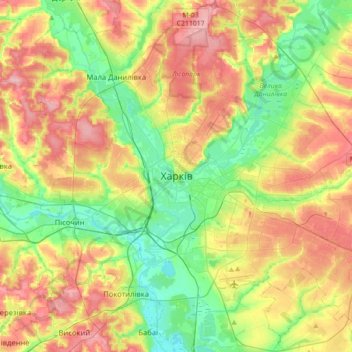
Name: Kharkiv topographic map, elevation, terrain.
Average elevation: 146 m
Minimum elevation: 92 m
Maximum elevation: 215 m
Based on Kharkiv's topography, the city can be conditionally divided into four lower districts and four higher districts.
Other topographic maps
Click on a map to view its topography, its elevation and its terrain.
Saltivskyi district
Ukraine > Kharkiv Oblast > Kharkiv
Saltivskyi district, Kharkiv, Kharkivska miska hromada, Kharkiv Raion, Kharkiv Oblast, Ukraine
Average elevation: 148 m
Pryvokzalne
Ukraine > Kharkiv Oblast > Pryvokzalne
Pryvokzalne, Valky Raion, Kharkiv Oblast, 63011, Ukraine
Average elevation: 200 m