
Zengcheng District topographic map
Interactive map
Click on the map to display elevation.
About this map
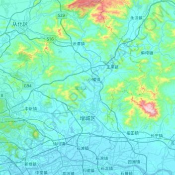
Name: Zengcheng District topographic map, elevation, terrain.
Average elevation: 106 m
Minimum elevation: -4 m
Maximum elevation: 1,251 m
Other topographic maps
Click on a map to view its topography, its elevation and its terrain.
Qiaotou Town
China > Guangdong Province > Dongguan
Qiaotou Town, Dongguan, Guangdong Province, China
Average elevation: 13 m
Luohu District
Luohu District, Shenzhen, Guangdong Province, 518000, China
Average elevation: 74 m
Qingyuan City
Qingyuan City, Guangdong Province, China
Average elevation: 349 m
Guangzhou City
Guangzhou City, Guangdong Province, China
Average elevation: 98 m
Yanluo Sub-district
China > Guangdong Province > Bao'an District > Yanluo Sub-district
Yanluo Sub-district, Bao'an District, Shenzhen, Guangdong Province, 518100, China
Average elevation: 40 m
Yuanling Sub-district
China > Guangdong Province > Futian District > Yuanling Sub-district
Yuanling Sub-district, Futian District, Shenzhen, Guangdong Province, 518000, China
Average elevation: 28 m
Hangcheng Sub-district
China > Guangdong Province > Bao'an District > Hangcheng Sub-district
Hangcheng Sub-district, Bao'an District, Shenzhen, Guangdong Province, 518100, China
Average elevation: 21 m