
Salerno topographic map
Interactive map
Click on the map to display elevation.
About this map
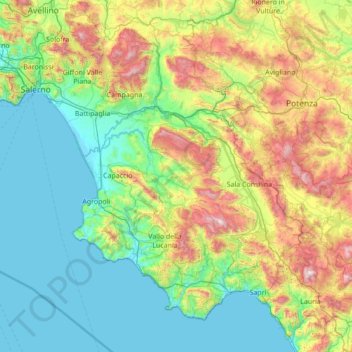
Name: Salerno topographic map, elevation, terrain.
Location: Salerno, Campania, Italy (39.99056 14.42830 40.84875 15.80645)
Average elevation: 464 m
Minimum elevation: -2 m
Maximum elevation: 1,987 m
Other topographic maps
Click on a map to view its topography, its elevation and its terrain.
Municipalità 10
Municipalità 10, Naples, NA, Campania, Italy
Average elevation: 44 m
Mount Vesuvius
Mount Vesuvius, Ercolano, NA, Campania, 80040, Italy
Average elevation: 863 m