
Stueng Hav topographic map
Interactive map
Click on the map to display elevation.
About this map
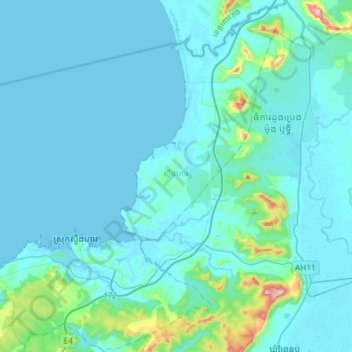
Name: Stueng Hav topographic map, elevation, terrain.
Location: Stueng Hav, Khaet Preah Sihanouk, Cambodia (10.65137 103.54208 10.94182 103.81446)
Average elevation: 26 m
Minimum elevation: -3 m
Maximum elevation: 305 m
Other topographic maps
Click on a map to view its topography, its elevation and its terrain.
Sihanoukville
Cambodia > Khaet Preah Sihanouk > Sihanoukville
Sihanoukville, Krong Preah Sihanouk, Khaet Preah Sihanouk, 18000, Cambodia
Average elevation: 14 m