
Kerala topographic map
Interactive map
Click on the map to display elevation.
About this map
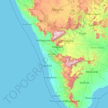
Name: Kerala topographic map, elevation, terrain.
Location: Kerala, India (8.29246 74.86407 12.79606 77.41194)
Average elevation: 251 m
Minimum elevation: -4 m
Maximum elevation: 2,557 m
Kerala was alternatively called Malabar in the foreign trade circles. Earlier, the term Malabar had also been used to denote Tulu Nadu and Kanyakumari which lie contiguous to Kerala on the southwestern coast of India, in addition to the modern state of Kerala. The people of Malabar were known as Malabars. Until the arrival of the East India Company, the term Malabar was used as a general name for Kerala, along with the term Kerala. From the time of Cosmas Indicopleustes (6th century CE) itself, the Arab sailors used to call Kerala as Male. The first element of the name, however, is attested already in the Topography written by Cosmas Indicopleustes. This mentions a pepper emporium called Male, which clearly gave its name to Malabar ('the country of Male'). The name Male is thought to come from the Malayalam word Mala ('hill'). Al-Biruni (973–1048 CE) is the first known writer to call this country Malabar. Authors such as Ibn Khordadbeh and Al-Baladhuri mention Malabar ports in their works. The Arab writers had called this place Malibar, Manibar, Mulibar, and Munibar. Malabar is reminiscent of the word Malanad which means the land of hills. According to William Logan, the word Malabar comes from a combination of the Malayalam word Mala (hill) and the Persian/Arabic word Barr (country/continent).
Other topographic maps
Click on a map to view its topography, its elevation and its terrain.
Elphinstone Point
India > Maharashtra > Mahabaleshwar > Dare
Elphinstone Point, Dare-NisanachiWaat, Dare, Mahabaleshwar, Satara, Maharashtra, India
Average elevation: 888 m
Hyderabad
India > Telangana > Bahadurpura mandal
Hyderabad, Bahadurpura mandal, Hyderabad District, Telangana, India
Average elevation: 549 m
Varanasi
India > Uttar Pradesh > Sadar
Varanasi, Sadar, Varanasi District, Uttar Pradesh, 221001, India
Average elevation: 77 m
Seijosa
Seijosa, Pakke-Kessang District, Arunachal Pradesh, India
Average elevation: 566 m
Cantonment
India > Madhya Pradesh > Ranjhi Tahsil
Cantonment, Ranjhi Tahsil, Jabalpur District, Madhya Pradesh, 482005, India
Average elevation: 421 m
Karimannoor
India > Kerala > Thodupuzha > Thommankutthu
Karimannoor, Thommankutthu, Thodupuzha, Idukki District, Kerala, 685581, India
Average elevation: 195 m
Kansai
India > Maharashtra > Shahade
Kansai, Shahade, Nandurbar, Maharashtra, India
Average elevation: 211 m
Atchutapuram
Atchutapuram, Anakapalli District, Andhra Pradesh, 531011, India
Average elevation: 29 m
Borramamidi
India > Andhra Pradesh > Chintapalle
Borramamidi, Chintapalle, Alluri Sitharama Raju District, Andhra Pradesh, 531123, India
Average elevation: 768 m
Avalpoondurai
India > Tamil Nadu > Modakkurichi
Avalpoondurai, Modakkurichi, Erode District, Tamil Nadu, 638115, India
Average elevation: 218 m
Ambala
India > Haryana > Ambala Cantt
Ambala, Ambala Cantt, Ambala District, Haryana, 134002, India
Average elevation: 275 m
Vengara
India > Kerala > Tirurangadi > kolappuram
Vengara, kolappuram, Tirurangadi, Malappuram District, Kerala, India
Average elevation: 57 m
Parad
India > Maharashtra > Murtijapur
Parad, Murtijapur, Akola, Maharashtra, India
Average elevation: 273 m
Vilappilsala
India > Kerala > Kattakkada
Vilappilsala, Kattakkada, Thiruvananthapuram District, Kerala, 695573, India
Average elevation: 71 m
Seema Puri Tehsil
Seema Puri Tehsil, Shahdara District, Delhi, 110093, India
Average elevation: 209 m
Chhina
India > Punjab > Amritsar II Tahsil
Chhina, Amritsar II Tahsil, Amritsar District, Punjab, 143113, India
Average elevation: 236 m
Chikkamagaluru
India > Karnataka > Chikkamagaluru taluku
Chikkamagaluru, Chikkamagaluru taluku, Chikkamagaluru District, Karnataka, 577101, India
Average elevation: 1,052 m
Perumbavoor
India > Kerala > Kunnathunad
Perumbavoor, Kunnathunad, Ernakulam District, Kerala, 683500, India
Average elevation: 20 m
Ernakulam
India > Kerala > Kanayannur
Ernakulam, Kanayannur, Ernakulam District, Kerala, 682035, India
Average elevation: 6 m
Nittur
India > Maharashtra > Chandgad
Nittur, Chandgad, Kolhapur, Maharashtra, 416508, India
Average elevation: 707 m
Leh
India > Ladakh > Leh Tehsil
Leh, Leh Tehsil, Leh District, Ladakh, India
Average elevation: 3,653 m
Dhana
India > Madhya Pradesh > Tendukheda Tahsil
Dhana, Tendukheda Tahsil, Damoh District, Madhya Pradesh, India
Average elevation: 372 m
Bangalore Urban
Bangalore Urban, Bengaluru Urban District, Karnataka, 560080, India
Average elevation: 790 m
Khasi Hills
India > Meghalaya > Mawshynrut
Khasi Hills, Mawshynrut, West Khasi Hills District, Meghalaya, India
Average elevation: 349 m
South District
South District, Namchi District, Sikkim, 737139, India
Average elevation: 2,687 m
Uttarkashi
India > Uttarakhand > Bhatwari
Uttarkashi, Bhatwari, Uttarkashi District, Uttarakhand, 249193, India
Average elevation: 1,619 m
Tumakuru
India > Karnataka > Tumkur taluk
Tumakuru, Tumkur taluk, Tumakuru District, Karnataka, 572101, India
Average elevation: 838 m
Nainital
India > Uttarakhand > Nainital
Nainital, Nainital District, Uttarakhand, 263003, India
Average elevation: 2,059 m
Spiti
Spiti, Lahaul and Spiti District, Himachal Pradesh, India
Average elevation: 4,906 m
Ankushapur
India > Telangana > Ghatkesar mandal
Ankushapur, Ghatkesar mandal, Medchal–Malkajgiri District, Telangana, 500088, India
Average elevation: 463 m
Kota
India > Rajasthan > Ladpura Tehsil
Kota, Ladpura Tehsil, Kota District, Rajasthan, 324001, India
Average elevation: 286 m