
Guangdong Province topographic map
Interactive map
Click on the map to display elevation.
About this map
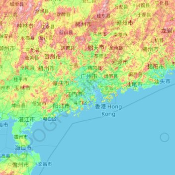
Name: Guangdong Province topographic map, elevation, terrain.
Location: Guangdong Province, China (20.11981 109.44948 25.51952 117.58023)
Average elevation: 194 m
Minimum elevation: -5 m
Maximum elevation: 1,988 m
Guangdong faces the South China Sea to the south and has a total of 4,300 km (2,700 mi) of coastline. The Leizhou Peninsula is on the southwestern end of the province. There are a few inactive volcanoes on Leizhou Peninsula. The Pearl River Delta is the convergent point of three upstream rivers: the East River, North River, and West River. The river delta is filled with hundreds of small islands. The province is geographically separated from the north by a few mountain ranges collectively called the Nan Mountains (Nan Ling). The highest peak in the province is Shikengkong with an elevation of 6,240 feet (1,902 meters) above sea level.
Other topographic maps
Click on a map to view its topography, its elevation and its terrain.
Qiaotou Town
China > Guangdong Province > Dongguan
Qiaotou Town, Dongguan, Guangdong Province, China
Average elevation: 13 m
Jinniu District
Jinniu District, Chengdu, Wuhou, Sichuan, China
Average elevation: 512 m
Tai Po
China > Hong Kong > Tai Po District
Tai Po, Tai Po District, New Territories, Hong Kong, China
Average elevation: 155 m
Macau
China > Macau > São Lourenço
Macau, São Lourenço, Municipality of Macau, Macau, 519020, China
Average elevation: 17 m
Luohu District
Luohu District, Shenzhen, Guangdong Province, 518000, China
Average elevation: 74 m
Qingyuan City
Qingyuan City, Guangdong Province, China
Average elevation: 349 m
Lhoka
China > Tibet > Tsetang Township
Lhoka, Tsetang Township, Nêdong District, Lhoka, Tibet, China
Average elevation: 4,148 m
Heihe
China > Heilongjiang > 幸福乡
Heihe, 幸福乡, Aihui District, Heihe City, Heilongjiang, 164300, China
Average elevation: 174 m
Chengguan District
Chengguan District, Lhasa, Tibet, 850000, China
Average elevation: 4,325 m
Ngawa Tibetan and Qiang Autonomous Prefecture
Ngawa Tibetan and Qiang Autonomous Prefecture, Sichuan, China
Average elevation: 3,542 m
Bishan District
Bishan District, Chongqing Main City Metropolitan Area, Chongqing, China
Average elevation: 344 m
Yushan
China > Jiangxi > Yushan County > Bingxi Subdistrict
Yushan, Bingxi Subdistrict, Yushan County, Shangrao, Jiangxi, China
Average elevation: 184 m
Guangzhou City
Guangzhou City, Guangdong Province, China
Average elevation: 98 m
Yiti
China > Sichuan > Ebian Yi Autonomous County
Yiti, Ebian Yi Autonomous County, Leshan City, Sichuan, China
Average elevation: 1,833 m
Maogang
China > Songjiang District > Maogang
Maogang, Songjiang District, Shanghai, China
Average elevation: 4 m
Islands District
Islands District, New Territories, Hong Kong, China
Average elevation: 36 m
Yanluo Sub-district
China > Guangdong Province > Bao'an District > Yanluo Sub-district
Yanluo Sub-district, Bao'an District, Shenzhen, Guangdong Province, 518100, China
Average elevation: 40 m
Junk Bay
China > Hong Kong > Sai Kung District > Tseung Kwan O
Junk Bay, Kwun Tong District, Tseung Kwan O, Sai Kung District, New Territories, Hong Kong, China
Average elevation: 29 m