
Livorno topographic map
Interactive map
Click on the map to display elevation.
About this map
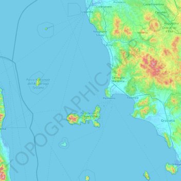
Name: Livorno topographic map, elevation, terrain.
Location: Livorno, Tuscany, Italy (42.31331 9.79129 43.63463 10.79622)
Average elevation: 61 m
Minimum elevation: -5 m
Maximum elevation: 1,188 m
Other topographic maps
Click on a map to view its topography, its elevation and its terrain.
Montepulciano
Montepulciano, Unione dei Comuni Valdichiana Senese, Siena, Tuscany, 53045, Italy
Average elevation: 374 m
Sesto Fiorentino
Italy > Tuscany > Sesto Fiorentino
Sesto Fiorentino, Metropolitan City of Florence, Tuscany, Italy
Average elevation: 187 m
Castel del Piano
Italy > Tuscany > Castel del Piano
Castel del Piano, Unione dei Comuni Montani Amiata Grossetana, GR, Tuscany, 58033, Italy
Average elevation: 561 m
Metropolitan City of Florence
Metropolitan City of Florence, Tuscany, Italy
Average elevation: 456 m