
Borough of Luton topographic map
Interactive map
Click on the map to display elevation.
About this map
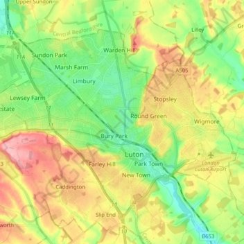
Name: Borough of Luton topographic map, elevation, terrain.
Location: Borough of Luton, England, United Kingdom (51.85447 -0.50595 51.92774 -0.34992)
Average elevation: 146 m
Minimum elevation: 94 m
Maximum elevation: 215 m
The local climate around Luton is differentiated somewhat from much of South East England due to its position in the Chiltern Hills, meaning it tends to be 1–2 degrees Celsius cooler than the surrounding towns – often flights at Luton airport, lying 160 m (525 ft) above sea level, will be suspended when marginal snow events occur, while airports at lower elevations, such as Heathrow, at 25 m (82 ft) above sea level, continue to function. An example of this is shown in the photograph to the right, the snowline being about 100 m (328 ft) above sea level. Absolute temperature extremes recorded at Rothamsted Research Station, 5 miles (8 km) south south east of Luton town centre and at a similar elevation range from −17.0 °C (1.4 °F) in December 1981 and −16.7 °C (1.9 °F) in January 1963 to 36.6 °C (97.9 °F) in July 2019 and 33.8 °C (92.8 °F) in August 1990 and July 2006. Records for Rothamsted date back to 1901.
Other topographic maps
Click on a map to view its topography, its elevation and its terrain.
London
United Kingdom > England > London
London, Greater London, England, SW1A 2DX, United Kingdom
Average elevation: 42 m
Bristol
United Kingdom > England > City of Bristol
Bristol, City of Bristol, West of England, England, United Kingdom
Average elevation: 55 m
Birmingham
Birmingham, West Midlands Combined Authority, England, United Kingdom
Average elevation: 138 m
Newcastle upon Tyne
Newcastle upon Tyne, North of Tyne, England, United Kingdom
Average elevation: 57 m
Greater Manchester
Greater Manchester, England, United Kingdom
Average elevation: 141 m
Bath
United Kingdom > England > Bath and North East Somerset
Bath, Bath and North East Somerset, West of England, England, United Kingdom
Average elevation: 100 m
Oxford
United Kingdom > England > Oxfordshire
Oxford, Oxfordshire, England, United Kingdom
Average elevation: 81 m
London
London, Greater London, England, United Kingdom
Average elevation: 66 m
Liverpool
Liverpool, Liverpool City Region, England, United Kingdom
Average elevation: 26 m
Clapham Common
United Kingdom > England > London
Clapham Common, Balham, London Borough of Wandsworth, London, Greater London, England, United Kingdom
Average elevation: 22 m
Hampstead Heath
United Kingdom > England > London
Hampstead Heath, Gospel Oak, London Borough of Camden, London, Greater London, England, United Kingdom
Average elevation: 94 m
Salisbury
United Kingdom > England > Salisbury
Salisbury, Wiltshire, South West England, England, SP1 1EU, United Kingdom
Average elevation: 96 m
Bournemouth
United Kingdom > England > Bournemouth, Christchurch and Poole > Wick
Bournemouth, Wick, Bournemouth, Christchurch and Poole, England, United Kingdom
Average elevation: 17 m
Richmond Park
United Kingdom > England > London
Richmond Park, London Borough of Richmond upon Thames, London, Greater London, England, United Kingdom
Average elevation: 26 m
Richmond
United Kingdom > England > London
Richmond, London, Greater London, England, TW9 1DY, United Kingdom
Average elevation: 17 m
Sheffield
Sheffield, South Yorkshire, England, United Kingdom
Average elevation: 168 m
Guildford
United Kingdom > England > Surrey
Guildford, Surrey, England, United Kingdom
Average elevation: 74 m
Sculthorpe
United Kingdom > England > Norfolk > North Norfolk
Sculthorpe, North Norfolk, Norfolk, England, United Kingdom
Average elevation: 47 m
Dartmoor National Park
United Kingdom > England > Devon
Dartmoor National Park, Devon, England, United Kingdom
Average elevation: 239 m
Taddington Dale
United Kingdom > England > Derbyshire > Derbyshire Dales > Brushfield CP
Taddington Dale, Brushfield CP, Derbyshire Dales, Derbyshire, England, United Kingdom
Average elevation: 281 m
Warminster
United Kingdom > England > Wiltshire
Warminster, Wiltshire, England, United Kingdom
Average elevation: 143 m
East Riding of Yorkshire
East Riding of Yorkshire, England, United Kingdom
Average elevation: 30 m
West Midlands
United Kingdom > England > Warwickshire
West Midlands, Warwickshire, West Midlands Combined Authority, England, United Kingdom
Average elevation: 113 m
Skipton
United Kingdom > England > Skipton
Skipton, North Yorkshire, Yorkshire and the Humber, England, BD23 1DU, United Kingdom
Average elevation: 201 m
Chesterfield
United Kingdom > England > Derbyshire
Chesterfield, Derbyshire, England, United Kingdom
Average elevation: 127 m
Norwich
United Kingdom > England > Norfolk
Norwich, Norfolk, England, United Kingdom
Average elevation: 28 m
Croydon
Croydon, Greater London, England, CR0 1SZ, United Kingdom
Average elevation: 70 m
Derby
United Kingdom > England > Derbyshire
Derby, Derbyshire, England, DE1 2AA, United Kingdom
Average elevation: 96 m
Cambridge
United Kingdom > England > Cambridgeshire
Cambridge, Cambridgeshire, Cambridgeshire and Peterborough, England, United Kingdom
Average elevation: 18 m
Bolton
Bolton, Greater Manchester, England, United Kingdom
Average elevation: 151 m
Loughborough
United Kingdom > England > Leicestershire > Charnwood
Loughborough, Charnwood, Leicestershire, England, LE11 5BJ, United Kingdom
Average elevation: 61 m
Colchester
United Kingdom > England > Essex
Colchester, Essex, England, United Kingdom
Average elevation: 28 m
Leicester
United Kingdom > England > Leicestershire
Leicester, Leicestershire, England, LE1 5YA, United Kingdom
Average elevation: 109 m
Kingston
United Kingdom > England > Dorset
Kingston, Corfe Castle, Dorset, England, BH20 5LH, United Kingdom
Average elevation: 86 m
Castleton
United Kingdom > England > Derbyshire > High Peak
Castleton, High Peak, Derbyshire, England, United Kingdom
Average elevation: 326 m
City of Bristol
City of Bristol, West of England, England, United Kingdom
Average elevation: 80 m
Northumberland
Northumberland, North of Tyne, England, United Kingdom
Average elevation: 141 m