
Las Matas topographic map
Interactive map
Click on the map to display elevation.
About this map
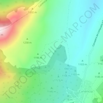
Name: Las Matas topographic map, elevation, terrain.
Location: Las Matas, Canencia, Sierra Norte, Comunidad de Madrid, España (40.90995 -3.75936 40.92995 -3.73936)
Average elevation: 1,187 m
Minimum elevation: 1,049 m
Maximum elevation: 1,532 m
Other topographic maps
Click on a map to view its topography, its elevation and its terrain.
Acebo del puerto de Canencia. Árbol singular de la Comunidad de Madrid Nº 76
España > Comunidad de Madrid > Canencia
Acebo del puerto de Canencia. Árbol singular de la Comunidad de Madrid Nº 76, Puente de la Pasada, Canencia, Sierra Norte, Comunidad de Madrid, España
Average elevation: 1,484 m