
Łódź topographic map
Interactive map
Click on the map to display elevation.
About this map
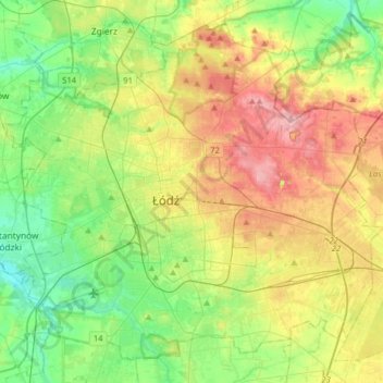
Name: Łódź topographic map, elevation, terrain.
Location: Łódź, Łódź Voivodeship, Poland (51.68614 19.32086 51.85983 19.63994)
Average elevation: 206 m
Minimum elevation: 158 m
Maximum elevation: 281 m
Other topographic maps
Click on a map to view its topography, its elevation and its terrain.
Troniny
Poland > Łódź Voivodeship > Troniny
Troniny, gmina Pątnów, powiat wieluński, Łódź Voivodeship, Poland
Average elevation: 189 m