
Faial Island topographic map
Interactive map
Click on the map to display elevation.
About this map
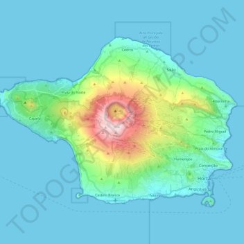
Name: Faial Island topographic map, elevation, terrain.
Location: Faial Island, Azores, Portugal (38.51516 -28.83479 38.64409 -28.59811)
Average elevation: 134 m
Minimum elevation: 0 m
Maximum elevation: 1,045 m
Faial has a humid subtropical climate with some Mediterranean influences, oceanic at higher altitudes. Average temperature is around 17–18 °C (63–64 °F), 20 °C (68 °F) at daytime and 15 °C (59 °F) at nighttime. It has very mild winters for its latitude, in part due to its location in the mid-Atlantic Ocean and infuence from the Gulf Stream, averaging 14 °C (57 °F) in its coldest month, February, and frosts never occur other than at high altitude. For comparison, Ocean City, Maryland, at a similar latitude, is 11.4 °C (52.5 °F) colder in its coldest month, averaging only 2.6 °C (36.7 °F). Summers are warm and relatively dry. Temperatures are moderated year-round, never too hot or too cold, daily temperatures are also moderated, with only 5 °C (41 °F) difference between highs and lows. Average relative humidity remains high at around 80% and insolation is relatively low with around 1800–1900 hours of annual sunshine, similar to locations in coastal northwestern Europe such as Nantes, France, although the sun is stronger in Faial because of its lower latitude. Precipitation is plentiful especially in the winter months, averaging 1,000 mm (39 in) annually. At higher altitudes (e.g. Caldeira Volcano) temperatures are cooler, precipitation and humidity are increasingly higher and fog is very common.
Other topographic maps
Click on a map to view its topography, its elevation and its terrain.
Glória e Vera Cruz
Glória e Vera Cruz, Aveiro, Portugal
Average elevation: 4 m
Vila Pequena
Portugal > Vila Real > Boticas > Dornelas
Vila Pequena, Dornelas, Boticas, Vila Real, Portugal
Average elevation: 779 m
Ermida
Portugal > Viana do Castelo > Ponte da Barca
Ermida, Ponte da Barca, Viana do Castelo, 4980-213, Portugal
Average elevation: 530 m
Ponte da Barca
Ponte da Barca, Viana do Castelo, Portugal
Average elevation: 362 m
Troviscal
Portugal > Castelo Branco > Sertã
Troviscal, Sertã, Castelo Branco, Portugal
Average elevation: 544 m
Benquerença
Portugal > Castelo Branco > Penamacor
Benquerença, Penamacor, Castelo Branco, Portugal
Average elevation: 519 m
Sistelo
Portugal > Viana do Castelo > Arcos de Valdevez
Sistelo, Arcos de Valdevez, Viana do Castelo, 4970-645, Portugal
Average elevation: 576 m
Vale de Nogueira
Vale de Nogueira, Lousã e Vilarinho, Lousã, Coimbra, 3200-901, Portugal
Average elevation: 388 m
Rates
Portugal > Porto > Póvoa de Varzim
Rates, Póvoa de Varzim, Porto, Portugal
Average elevation: 78 m
Alqueidão da Serra
Portugal > Leiria > Porto de Mós
Alqueidão da Serra, Porto de Mós, Leiria, Portugal
Average elevation: 314 m
Praia do Beliche
Praia do Beliche, Sagres, Vila do Bispo, Faro, Portugal
Average elevation: 29 m
Pico Ruivo
Pico Ruivo, Santana, Madeira, 9030-311, Portugal
Average elevation: 1,400 m
Quinta do Bispo
Portugal > Leiria > Pombal > Abiul
Quinta do Bispo, Abiul, Pombal, Leiria, Portugal
Average elevation: 218 m
São Paio de Cima
Portugal > Braga > Esposende > Antas
São Paio de Cima, Antas, Esposende, Braga, 4740-438, Portugal
Average elevation: 113 m
Foz do Tua
Portugal > Bragança > Carrazeda de Ansiães
Foz do Tua, Castanheiro do Norte e Ribalonga, Carrazeda de Ansiães, Bragança, Portugal
Average elevation: 279 m
Santo Quintino
Portugal > Lisbon > Sobral de Monte Agraço
Santo Quintino, Sobral de Monte Agraço, Lisbon, Portugal
Average elevation: 245 m
Santa Bárbara
Santa Bárbara, Ponta Delgada, Azores, Portugal
Average elevation: 272 m