
Pieszyce topographic map
Interactive map
Click on the map to display elevation.
About this map
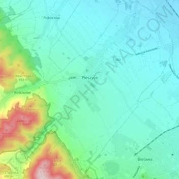
Name: Pieszyce topographic map, elevation, terrain.
Average elevation: 337 m
Minimum elevation: 253 m
Maximum elevation: 663 m
Other topographic maps
Click on a map to view its topography, its elevation and its terrain.
Ostroszowice
Poland > Lower Silesian Voivodeship > Dzierżoniów County
Ostroszowice, gmina Dzierżoniów, Dzierżoniów County, Lower Silesian Voivodeship, 58-262, Poland
Average elevation: 415 m
Jodłownik
Poland > Lower Silesian Voivodeship > Dzierżoniów County > Ostroszowice
Jodłownik, Ostroszowice, gmina Dzierżoniów, Dzierżoniów County, Lower Silesian Voivodeship, Poland
Average elevation: 445 m
Czernica
Poland > Lower Silesian Voivodeship > Dzierżoniów County > Jaźwina
Czernica, Jaźwina, gmina Łagiewniki, Dzierżoniów County, Lower Silesian Voivodeship, 58-212, Poland
Average elevation: 361 m