
Cerredo topographic map
Interactive map
Click on the map to display elevation.
About this map
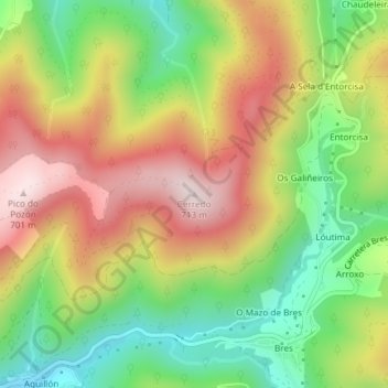
Name: Cerredo topographic map, elevation, terrain.
Location: Cerredo, Taramundi, Asturias, 33775, España (43.38020 -7.07331 43.38030 -7.07321)
Average elevation: 449 m
Minimum elevation: 219 m
Maximum elevation: 703 m
Other topographic maps
Click on a map to view its topography, its elevation and its terrain.
A Veiga da Sarza
A Veiga da Sarza, Taramundi, Asturias, 33775, España
Average elevation: 354 m
Os Teixóis
España > Asturias > Taramundi > Os Teixóis
Os Teixóis, Taramundi, Asturias, 33775, España
Average elevation: 540 m