
Gwalior topographic map
Interactive map
Click on the map to display elevation.
About this map
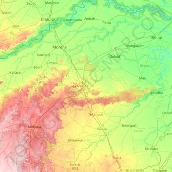
Name: Gwalior topographic map, elevation, terrain.
Location: Gwalior, Madhya Pradesh, 474002, India (25.56000 77.56000 26.84000 78.84000)
Average elevation: 217 m
Minimum elevation: 106 m
Maximum elevation: 472 m
Other topographic maps
Click on a map to view its topography, its elevation and its terrain.
Cantonment
India > Madhya Pradesh > Ranjhi Tahsil
Cantonment, Ranjhi Tahsil, Jabalpur District, Madhya Pradesh, 482005, India
Average elevation: 421 m
Dhana
India > Madhya Pradesh > Tendukheda Tahsil
Dhana, Tendukheda Tahsil, Damoh District, Madhya Pradesh, India
Average elevation: 372 m
Narmada
Narmada, Hoshangābād, Hoshangabad, Madhya Pradesh, 481880, India
Average elevation: 380 m