
Drumheller (town) topographic map
Interactive map
Click on the map to display elevation.
About this map
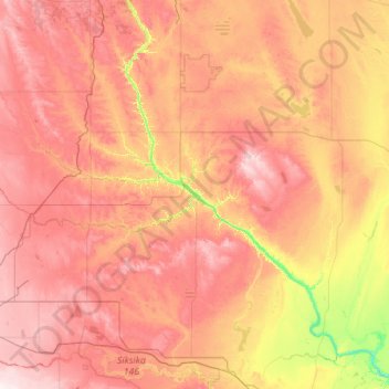
Name: Drumheller (town) topographic map, elevation, terrain.
Location: Drumheller (town), Alberta, T0J 2V0, Canadá (50.77693 -113.28024 52.05693 -112.00024)
Average elevation: 855 m
Minimum elevation: 637 m
Maximum elevation: 1,086 m
Other topographic maps
Click on a map to view its topography, its elevation and its terrain.
Río Athabasca
Río Athabasca, Municipal District of Lesser Slave River, Alberta, T9S 1H4, Canadá
Average elevation: 696 m