
Rocky Point topographic map
Interactive map
Click on the map to display elevation.
About this map
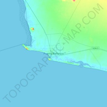
Name: Rocky Point topographic map, elevation, terrain.
Location: Rocky Point, Sonora, 83550, Mexico (31.15709 -113.69182 31.47709 -113.37182)
Average elevation: 9 m
Minimum elevation: -3 m
Maximum elevation: 122 m
The city of Puerto Peñasco (Rocky Point) is found in the northwest of the Mexican state of Sonora, a state that is located directly to the south of the U.S. state of Arizona. It is located on the eastern coast of the Gulf of California approximately 60 miles south of the Arizonan border, only about a four-hour drive from Phoenix or Tucson. The city's maximum elevation is 100 meters (328 feet) above sea level and its minimum is 0 meters (0 feet) above sea level. It is found in the Sonoran Desert, a desert which stretches from the U.S. states of Arizona and California down to the northern tip of the Mexican state of Sinaloa. Because of this, its climate reaches extreme temperatures during the summer and relatively high temperatures in the winter. The city itself is relatively flat, with the exception of Ballena hill that is found near its port. Further, remnants of ancient volcanoes can be found on the beaches of Puerto Peñasco and several dormant volcano peaks can be seen throughout the entire state.