
Capanema topographic map
Interactive map
Click on the map to display elevation.
About this map
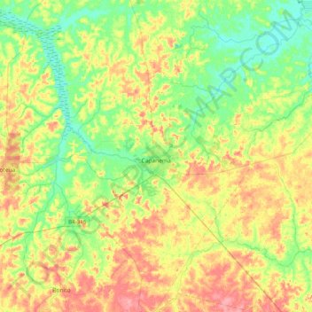
Name: Capanema topographic map, elevation, terrain.
Average elevation: 32 m
Minimum elevation: 0 m
Maximum elevation: 77 m
'Capanema' is a municipality in the state of Pará. It is located at a latitude 01 ° 11'45 "South and longitude 47 ° 10'51" west, with an altitude of 24 meters. Its population in 2020 was 69,431 inhabitants. Despite being a city average, requires great influence in the region in trade and services. A receptive and lively city, where it became home to many immigrants from various regions of Brazil, mainly from Northeast.
Other topographic maps
Click on a map to view its topography, its elevation and its terrain.
Rio Grande
Rio Grande, Benção de Deus, Curuçá, Região Geográfica Imediata de Castanhal, Região Geográfica Intermediária de Castanhal, Pará, North Region, 68750-000, Brazil
Average elevation: 15 m
São Félix do Xingu
São Félix do Xingu, Tapajós, Microrregião de São Felix do Xingu, Mesorregião Sudeste Paraense, Pará, North Region, Brazil
Average elevation: 334 m