
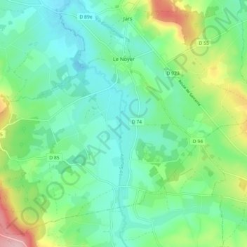
Le Noyer topographic map
Interactive map
Click on the map to display elevation.
About this map
Name: Le Noyer topographic map, elevation, terrain.
Average elevation: 256 m
Minimum elevation: 206 m
Maximum elevation: 388 m
Other topographic maps
Click on a map to view its topography, its elevation and its terrain.
Bourges
France > Centre-Val de Loire > Cher
Bourges, Cher, Centre-Val de Loire, France métropolitaine, 18000, France
Average elevation: 146 m
Chéry
France > Centre-Val de Loire > Cher
Chéry, Vierzon, Cher, Centre-Val de Loire, France métropolitaine, 18120, France
Average elevation: 127 m
Méreau
France > Centre-Val de Loire > Cher
Méreau, Vierzon, Cher, Centre-Val de Loire, France métropolitaine, 18120, France
Average elevation: 117 m
Chanteloup
France > Centre-Val de Loire > Cher > Lunery
Chanteloup, Lunery, Bourges, Cher, Centre-Val de Loire, France métropolitaine, 18400, France
Average elevation: 146 m
Jouet-sur-l'Aubois
France > Centre-Val de Loire > Cher
Jouet-sur-l'Aubois, Saint-Amand-Montrond, Cher, Centre-Val de Loire, France métropolitaine, 18320, France
Average elevation: 187 m
Mehun-sur-Yèvre
France > Centre-Val de Loire > Cher
Mehun-sur-Yèvre, Vierzon, Cher, Centre-Val de Loire, France métropolitaine, 18500, France
Average elevation: 122 m
Saulzais-le-Potier
France > Centre-Val de Loire > Cher
Saulzais-le-Potier, Saint-Amand-Montrond, Cher, Centre-Val de Loire, France métropolitaine, 18360, France
Average elevation: 224 m
Saint-Baudel
France > Centre-Val de Loire > Cher
Saint-Baudel, Saint-Amand-Montrond, Cher, Centre-Val de Loire, France métropolitaine, 18160, France
Average elevation: 164 m
Ménétréol-sous-Sancerre
France > Centre-Val de Loire > Cher
Ménétréol-sous-Sancerre, Bourges, Cher, Centre-Val de Loire, France métropolitaine, 18300, France
Average elevation: 189 m
Plaimpied-Givaudins
France > Centre-Val de Loire > Cher
Plaimpied-Givaudins, Bourges, Cher, Centre-Val de Loire, France métropolitaine, 18340, France
Average elevation: 157 m
Brinon-sur-Sauldre
France > Centre-Val de Loire > Cher
Brinon-sur-Sauldre, Vierzon, Cher, Centre-Val de Loire, France métropolitaine, 18410, France
Average elevation: 143 m
18340
France > Centre-Val de Loire > Cher > Levet
18340, Levet, Bourges, Cher, Centre-Val de Loire, France métropolitaine, France
Average elevation: 173 m
Lustambourg
France > Centre-Val de Loire > Cher > Baugy
Lustambourg, Saligny-le-Vif, Baugy, Bourges, Cher, Centre-Val de Loire, France métropolitaine, 18800, France
Average elevation: 201 m
Garigny
France > Centre-Val de Loire > Cher
Garigny, Bourges, Cher, Centre-Val de Loire, France métropolitaine, 18140, France
Average elevation: 185 m
Baugy
France > Centre-Val de Loire > Cher
Baugy, Bourges, Cher, Centre-Val de Loire, France métropolitaine, 18800, France
Average elevation: 186 m
Sancergues
France > Centre-Val de Loire > Cher
Sancergues, Bourges, Cher, Centre-Val de Loire, France métropolitaine, 18140, France
Average elevation: 183 m
La Bellevue
France > Centre-Val de Loire > Cher > Cuffy
La Bellevue, Cuffy, Saint-Amand-Montrond, Cher, Centre-Val de Loire, France métropolitaine, 18150, France
Average elevation: 185 m
Mornay-sur-Allier
France > Centre-Val de Loire > Cher
Mornay-sur-Allier, Saint-Amand-Montrond, Cher, Centre-Val de Loire, France métropolitaine, 18600, France
Average elevation: 199 m
Rians
France > Centre-Val de Loire > Cher
Rians, Bourges, Cher, Centre-Val de Loire, France métropolitaine, 18220, France
Average elevation: 186 m
Allogny
France > Centre-Val de Loire > Cher
Allogny, Bourges, Cher, Centre-Val de Loire, France métropolitaine, 18110, France
Average elevation: 206 m
Loye-sur-Arnon
France > Centre-Val de Loire > Cher
Loye-sur-Arnon, Saint-Amand-Montrond, Cher, Centre-Val de Loire, France métropolitaine, 18170, France
Average elevation: 225 m
Vernais
France > Centre-Val de Loire > Cher
Vernais, Saint-Amand-Montrond, Cher, Centre-Val de Loire, France métropolitaine, 18210, France
Average elevation: 195 m
Sancerre
France > Centre-Val de Loire > Cher
Sancerre, Bourges, Cher, Centre-Val de Loire, France métropolitaine, 18300, France
Average elevation: 212 m
Vesdun
France > Centre-Val de Loire > Cher
Vesdun, Saint-Amand-Montrond, Cher, Centre-Val de Loire, France métropolitaine, 18360, France
Average elevation: 274 m
Le Gravier
France > Centre-Val de Loire > Cher > La Guerche-sur-l'Aubois
Le Gravier, La Guerche-sur-l'Aubois, Saint-Amand-Montrond, Cher, Centre-Val de Loire, France métropolitaine, 18150, France
Average elevation: 196 m
Les Mabilats
France > Centre-Val de Loire > Cher > Vierzon
Les Mabilats, Vierzon, Cher, Centre-Val de Loire, France métropolitaine, 18100, France
Average elevation: 138 m
Couargues
France > Centre-Val de Loire > Cher
Couargues, Bourges, Cher, Centre-Val de Loire, France métropolitaine, 18300, France
Average elevation: 166 m
Charenton-du-Cher
France > Centre-Val de Loire > Cher
Charenton-du-Cher, Saint-Amand-Montrond, Cher, Centre-Val de Loire, France métropolitaine, 18210, France
Average elevation: 203 m
Loye
France > Centre-Val de Loire > Cher > Morogues
Loye, Morogues, Bourges, Cher, Centre-Val de Loire, France métropolitaine, 18220, France
Average elevation: 239 m
Gron
France > Centre-Val de Loire > Cher
Gron, Bourges, Cher, Centre-Val de Loire, France métropolitaine, 18800, France
Average elevation: 194 m
Sens-Beaujeu
France > Centre-Val de Loire > Cher
Sens-Beaujeu, Bourges, Cher, Centre-Val de Loire, France métropolitaine, 18300, France
Average elevation: 281 m
Thaumiers
France > Centre-Val de Loire > Cher
Thaumiers, Saint-Amand-Montrond, Cher, Centre-Val de Loire, France métropolitaine, 18210, France
Average elevation: 191 m
Morlac
France > Centre-Val de Loire > Cher
Morlac, Saint-Amand-Montrond, Cher, Centre-Val de Loire, France métropolitaine, 18170, France
Average elevation: 191 m
Épineuil-le-Fleuriel
France > Centre-Val de Loire > Cher
Épineuil-le-Fleuriel, Saint-Amand-Montrond, Cher, Centre-Val de Loire, France métropolitaine, 18360, France
Average elevation: 206 m
Jussy-Champagne
France > Centre-Val de Loire > Cher
Jussy-Champagne, Bourges, Cher, Centre-Val de Loire, France métropolitaine, 18130, France
Average elevation: 180 m
Saint-Hilaire-de-Court
France > Centre-Val de Loire > Cher
Saint-Hilaire-de-Court, Vierzon, Cher, Centre-Val de Loire, France métropolitaine, 18100, France
Average elevation: 109 m
Saint-Hilaire-en-Lignières
France > Centre-Val de Loire > Cher
Saint-Hilaire-en-Lignières, Saint-Amand-Montrond, Cher, Centre-Val de Loire, France métropolitaine, 18160, France
Average elevation: 190 m
Farges-en-Septaine
France > Centre-Val de Loire > Cher
Farges-en-Septaine, Bourges, Cher, Centre-Val de Loire, France métropolitaine, 18800, France
Average elevation: 172 m
Le Bessin
France > Centre-Val de Loire > Cher > Morlac
Le Bessin, Morlac, Saint-Amand-Montrond, Cher, Centre-Val de Loire, France métropolitaine, 18170, France
Average elevation: 198 m
Mornay-Berry
France > Centre-Val de Loire > Cher
Mornay-Berry, Saint-Amand-Montrond, Cher, Centre-Val de Loire, France métropolitaine, 18350, France
Average elevation: 200 m
Corquoy
France > Centre-Val de Loire > Cher > Corquoy
Corquoy, Saint-Amand-Montrond, Cher, Centre-Val de Loire, France métropolitaine, 18190, France
Average elevation: 158 m
Herry
France > Centre-Val de Loire > Cher
Herry, Bourges, Cher, Centre-Val de Loire, France métropolitaine, 18140, France
Average elevation: 165 m
Mareuil-sur-Arnon
France > Centre-Val de Loire > Cher
Mareuil-sur-Arnon, Bourges, Cher, Centre-Val de Loire, France métropolitaine, 18290, France
Average elevation: 156 m
Barlieu
France > Centre-Val de Loire > Cher
Barlieu, Bourges, Cher, Centre-Val de Loire, France métropolitaine, 18260, France
Average elevation: 230 m
Verdigny
France > Centre-Val de Loire > Cher
Verdigny, Bourges, Cher, Centre-Val de Loire, France métropolitaine, 18300, France
Average elevation: 259 m
Châteauneuf-sur-Cher
France > Centre-Val de Loire > Cher
Châteauneuf-sur-Cher, Saint-Amand-Montrond, Cher, Centre-Val de Loire, France métropolitaine, 18190, France
Average elevation: 160 m
Villequiers
France > Centre-Val de Loire > Cher
Villequiers, Bourges, Cher, Centre-Val de Loire, France métropolitaine, 18800, France
Average elevation: 192 m
Germigny-l'Exempt
France > Centre-Val de Loire > Cher
Germigny-l'Exempt, Saint-Amand-Montrond, Cher, Centre-Val de Loire, France métropolitaine, 18150, France
Average elevation: 198 m
Le Champ du Noyer
France > Centre-Val de Loire > Cher > Vailly-sur-Sauldre
Le Champ du Noyer, Vailly-sur-Sauldre, Bourges, Cher, Centre-Val de Loire, France métropolitaine, 18260, France
Average elevation: 229 m
Méry-ès-Bois
France > Centre-Val de Loire > Cher
Méry-ès-Bois, Vierzon, Cher, Centre-Val de Loire, France métropolitaine, 18380, France
Average elevation: 220 m