
Hollola topographic map
Interactive map
Click on the map to display elevation.
About this map
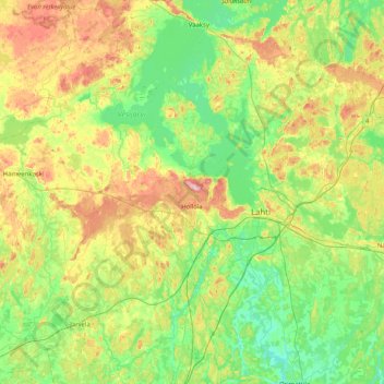
Name: Hollola topographic map, elevation, terrain.
Average elevation: 108 m
Minimum elevation: 58 m
Maximum elevation: 219 m
Other topographic maps
Click on a map to view its topography, its elevation and its terrain.
Asikkala
Asikkala, Lahti sub-region, Päijät-Häme, Southern Finland, Mainland Finland, Finland
Average elevation: 105 m