
Glenarm topographic map
Interactive map
Click on the map to display elevation.
About this map
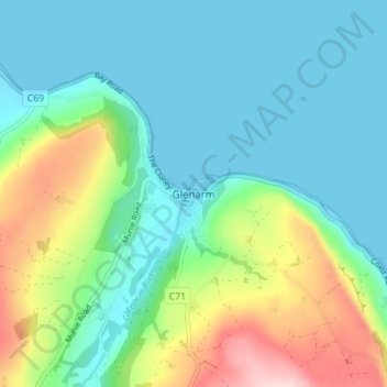
Name: Glenarm topographic map, elevation, terrain.
Average elevation: 67 m
Minimum elevation: -1 m
Maximum elevation: 257 m
Other topographic maps
Click on a map to view its topography, its elevation and its terrain.
Demense Upper
United Kingdom > Northern Ireland > Glenarm
Demense Upper, Glenarm, County Antrim, Northern Ireland, United Kingdom
Average elevation: 84 m