
Limoges topographic map
Interactive map
Click on the map to display elevation.
About this map
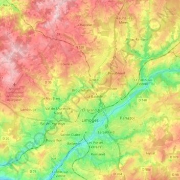
Name: Limoges topographic map, elevation, terrain.
Average elevation: 322 m
Minimum elevation: 204 m
Maximum elevation: 439 m
Other topographic maps
Click on a map to view its topography, its elevation and its terrain.
Lajat
France > Nouvelle-Aquitaine > Haute-Vienne > Saint-Léonard-de-Noblat
Lajat, Saint-Léonard-de-Noblat, Limoges, Haute-Vienne, Nouvelle-Aquitaine, Metropolitan France, 87400, France
Average elevation: 324 m