
Zamboanga City topographic map
Interactive map
Click on the map to display elevation.
About this map
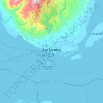
Name: Zamboanga City topographic map, elevation, terrain.
Location: Zamboanga City, Zamboanga Peninsula, 7000, Philippines (6.74460 121.91637 7.06460 122.23637)
Average elevation: 83 m
Minimum elevation: -2 m
Maximum elevation: 1,201 m
The overall topography of the city could be described as rolling to very steep. There are some flat lands, mostly narrow strips along the east coast. The urban center is mostly flat with a gentle slope to the interior, ranging from 0% to 3%. A portion, about 38,000 hectares, has slopes ranging from 18% to 30%. Another 26,000 hectares has slopes of less than 3%, while about 37% of the area (a total of 52,000 hectares) has slopes ranging from 30% to more than 50%. The highest registered elevation is 1,200 metres.