
Taos County topographic map
Interactive map
Click on the map to display elevation.
About this map
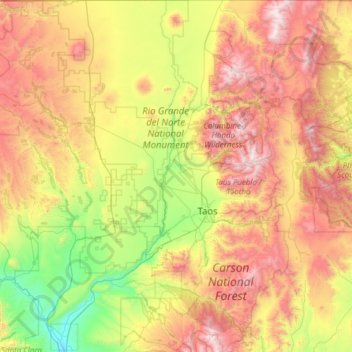
Name: Taos County topographic map, elevation, terrain.
Location: Taos County, New Mexico, United States of America (36.01287 -106.05840 36.99597 -105.20011)
Average elevation: 2,561 m
Minimum elevation: 1,709 m
Maximum elevation: 3,980 m
The county's highest point is the summit of Wheeler Peak at 13,161 feet (4,011 m). This is also the highest natural point in New Mexico. The county has the highest mean elevation of any U.S. county outside of Colorado at 8,510 feet (2,590 m), even though it ranks only 22nd overall. Taos County contains 17 of New Mexico's highest 25 peaks.
Other topographic maps
Click on a map to view its topography, its elevation and its terrain.
Doña Ana County
United States of America > New Mexico
Doña Ana County, New Mexico, United States of America
Average elevation: 1,349 m
Santa Fe County
United States of America > New Mexico
Santa Fe County, New Mexico, United States of America
Average elevation: 2,177 m