
Gaborone topographic map
Interactive map
Click on the map to display elevation.
About this map
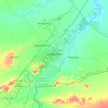
Name: Gaborone topographic map, elevation, terrain.
Location: Gaborone, South-East District, 09267, Botswana (-24.81814 25.74885 -24.49814 26.06885)
Average elevation: 1,032 m
Minimum elevation: 946 m
Maximum elevation: 1,364 m
Other topographic maps
Click on a map to view its topography, its elevation and its terrain.
Gaborone Dam
Botswana > South-East District > Gaborone
Gaborone Dam, Gaborone, South-East District, Botswana
Average elevation: 992 m