
Kvåsfossen topographic map
Interactive map
Click on the map to display elevation.
About this map
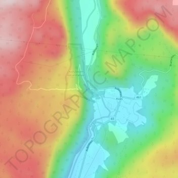
Name: Kvåsfossen topographic map, elevation, terrain.
Location: Kvåsfossen, Lyngdal, West Agder, 4588, Norway (58.26454 7.18976 58.26464 7.18986)
Average elevation: 236 m
Minimum elevation: 42 m
Maximum elevation: 453 m
Other topographic maps
Click on a map to view its topography, its elevation and its terrain.
Gorži - Fossen
Gorži - Fossen, Kåfjord, Troms og Finnmark, 9144, Norway
Average elevation: 293 m
Lillehammer
Norway > Innlandet > Lillehammer
Lillehammer, Innlandet, 2609, Norway
Average elevation: 360 m
Tyrifjorden
Tyrifjorden, Øst-Modumveien, Vefsrud, Lier, Buskerud, Norway
Average elevation: 265 m
Finnmark
Finnmark, Bamble, Vestfold og Telemark, 3967, Norway
Average elevation: 38 m