
Nias topographic map
Interactive map
Click on the map to display elevation.
About this map
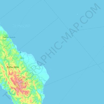
Name: Nias topographic map, elevation, terrain.
Location: Nias, North Sumatra, Indonesia (0.88374 97.48352 1.45130 98.33944)
Average elevation: 39 m
Minimum elevation: 0 m
Maximum elevation: 838 m
Other topographic maps
Click on a map to view its topography, its elevation and its terrain.
Helvetia
Indonesia > North Sumatra > Deli Serdang
Helvetia, Deli Serdang, North Sumatra, 20239, Indonesia
Average elevation: 15 m
Lake Toba
Indonesia > North Sumatra > Silima Lombu
Lake Toba, Under construction, Silima Lombu, Samosir, North Sumatra, Indonesia
Average elevation: 1,079 m
Medan Baru
Indonesia > North Sumatra > City of Medan
Medan Baru, City of Medan, North Sumatra, Indonesia
Average elevation: 29 m
Mandailing Natal
Mandailing Natal, North Sumatra, 22919, Indonesia
Average elevation: 235 m
Guntung
Indonesia > North Sumatra > Guntung
Guntung, Batu Bara, North Sumatra, Indonesia
Average elevation: 3 m
Dolok Simanukmanuk
Indonesia > North Sumatra > Pematang Siantar
Dolok Simanukmanuk, Pematang Siantar, North Sumatra, Indonesia
Average elevation: 1,785 m
Tebing Tinggi
Indonesia > North Sumatra > Tebing Tinggi
Tebing Tinggi, Kota Tebing Tinggi–Serdang Bedagai, North Sumatra, 20600, Indonesia
Average elevation: 34 m
Medan Kota
Indonesia > North Sumatra > City of Medan
Medan Kota, City of Medan, North Sumatra, Indonesia
Average elevation: 28 m
Samosir
Samosir, North Sumatra, Sumatra, Indonesia
Average elevation: 1,215 m