
County Wicklow topographic map
Interactive map
Click on the map to display elevation.
About this map
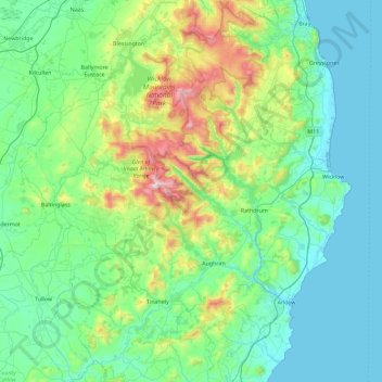
Name: County Wicklow topographic map, elevation, terrain.
Location: County Wicklow, Leinster, Ierland (52.68198 -6.79229 53.23431 -5.99758)
Average elevation: 166 m
Minimum elevation: 0 m
Maximum elevation: 927 m
Other topographic maps
Click on a map to view its topography, its elevation and its terrain.
Dún Laoghaire
Dún Laoghaire, Dún Laoghaire-Rathdown, County Dublin, Leinster, A96 T860, Ierland
Average elevation: 21 m
Bantry
Bantry, West Cork, County Cork, Munster, P75 AE30, Ierland
Average elevation: 67 m
Hill of Tara
Hill of Tara, The Municipal District of Ashbourne, County Meath, Leinster, C15 NYY6, Ierland
Average elevation: 106 m
Muckalee
Muckalee, The Municipal District of Castlecomer, County Kilkenny, Leinster, Ierland
Average elevation: 150 m
The Municipal District of Borris-in-Ossory — Mountmellick
The Municipal District of Borris-in-Ossory — Mountmellick, County Laois, Leinster, Ierland
Average elevation: 132 m
Malin Head
Malin Head, Ardmalin ED, Inishowen Municipal District, County Donegal, Ierland
Average elevation: 4 m
Waterford City Metropolitan District
Waterford City Metropolitan District, County Waterford, Munster, Ierland
Average elevation: 29 m
Galway Municipal District
Ierland > County Galway > Galway (stad)
Galway Municipal District, Galway (stad), County Galway, Connacht, Ierland
Average elevation: 15 m
Been
Been, Kilnamanagh, West Cork, County Cork, Munster, P75 K722, Ierland
Average elevation: 11 m
Ballyjamesduff Municipal District
Ballyjamesduff Municipal District, County Cavan, Ierland
Average elevation: 100 m
Lislorkan North
Lislorkan North, Ballysteen, West Clare Municipal District, County Clare, Munster, Ierland
Average elevation: 93 m
Cathair na Gaillimhe
Ierland > Cathair na Gaillimhe
Galway, Cathair na Gaillimhe, County Galway, Connacht, H91 YD86, Ierland
Average elevation: 26 m
Clondalkin
Clondalkin, South Dublin, County Dublin, Leinster, D22 V6Y6, Ierland
Average elevation: 69 m
Brownsbarn
Brownsbarn, Clondalkin-Village ED, Saggart, South Dublin, County Dublin, Leinster, D22W1H9, Ierland
Average elevation: 102 m
Castlepoint
Castlepoint, Lowertown, West Cork, County Cork, Munster, Ierland
Average elevation: 11 m
Ballynash
Ierland > The Municipal District of Adare — Rathkeale
Ballynash, Iveruss, The Municipal District of Adare — Rathkeale, County Limerick, Munster, Ierland
Average elevation: 5 m
Cherry Orchard
Cherry Orchard, Merchants Quay E ED, Dublin 8, Dublin, County Dublin, Leinster, Ierland
Average elevation: 25 m
Great Skellig
Great Skellig, Kenmare Municipal District, County Kerry, Munster, Ierland
Average elevation: 1 m
Brockagh
Brockagh, Glendalough, County Wicklow, Leinster, Ierland
Average elevation: 284 m
Dingle - Daingean Uí Chúis
Ierland > Dingle - Daingean Uí Chúis
Dingle - Daingean Uí Chúis, County Kerry, Munster, Ierland
Average elevation: 77 m