Aubigny-sur-Nère topographic map
Interactive map
Click on the map to display elevation.
About this map
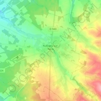
Name: Aubigny-sur-Nère topographic map, elevation, terrain.
Average elevation: 200 m
Minimum elevation: 158 m
Maximum elevation: 267 m

Click on the map to display elevation.
Name: Aubigny-sur-Nère topographic map, elevation, terrain.
Average elevation: 200 m
Minimum elevation: 158 m
Maximum elevation: 267 m