
Baja California topographic map
Interactive map
Click on the map to display elevation.
About this map
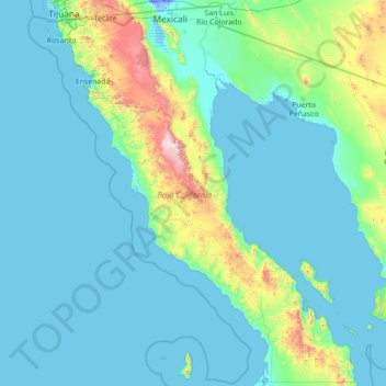
Name: Baja California topographic map, elevation, terrain.
Location: Baja California, Mexico (27.99999 -118.36506 32.71867 -112.75267)
Average elevation: 179 m
Minimum elevation: -11 m
Maximum elevation: 2,850 m
Baja California is the 12th-largest state by area in Mexico. Its geography ranges from beaches to forests and deserts. The backbone of the state is the Sierra de Baja California, where Picacho del Diablo, the highest point of the peninsula, is located. This mountain range effectively divides the weather patterns in the state. In the northwest, the weather is semi-dry and Mediterranean. In the narrow center, the weather changes to be more humid due to altitude. It is in this area where a few valleys can be found, such as the Valle de Guadalupe, the major wine-producing area in Mexico. To the east of the mountain range, the Sonoran Desert dominates the landscape. In the south, the weather becomes drier and gives way to the Vizcaíno Desert. The state is also home to numerous islands off both of its shores. Baja California is also home to Guadalupe Island, the westernmost point of Mexico. The Coronado Islands, Todos Santos islands, and Cedros Island are also on the Pacific shore. On the Gulf of California, the largest island is Angel de la Guarda Island, separated from the peninsula by the deep and narrow Canal de Ballenas.
Other topographic maps
Click on a map to view its topography, its elevation and its terrain.
Monterrey
Mexico > Nuevo León > Monterrey > Monterrey
Monterrey, Nuevo León, 64570, Mexico
Average elevation: 753 m
Mexico City
Mexico > Mexico City > Mexico City
Mexico City, Cuauhtémoc, Mexico City, 06060, Mexico
Average elevation: 2,321 m
San Miguel de Allende
Mexico > Guanajuato > San Miguel de Allende
San Miguel de Allende, Guanajuato, Mexico
Average elevation: 1,964 m
Marfil
Mexico > Guanajuato > Municipio de Guanajuato
Marfil, Municipio de Guanajuato, Guanajuato, 36250, Mexico
Average elevation: 2,045 m
Papalotla
Papalotla, State of Mexico, 56050, Mexico
Average elevation: 2,265 m
Texcoco de Mora
Mexico > State of Mexico > Texcoco
Texcoco de Mora, Texcoco, State of Mexico, 56100, Mexico
Average elevation: 2,448 m
Ramos Arizpe
Mexico > Coahuila > Ramos Arizpe
Ramos Arizpe, Coahuila, 25900, Mexico
Average elevation: 1,426 m
Santiago Matatlán
Mexico > Oaxaca > Santiago Matatlán
Santiago Matatlán, Oaxaca, Mexico
Average elevation: 1,760 m
San Luis del Río
Mexico > Oaxaca > Tlacolula de Matamoros
San Luis del Río, Tlacolula de Matamoros, Oaxaca, Mexico
Average elevation: 1,159 m
Pueblo Viejo
Pueblo Viejo, Temixco, Morelos, 62588, Mexico
Average elevation: 1,351 m
Aguas Calientes
Mexico > Guerrero > Acapulco de Juárez
Aguas Calientes, Acapulco de Juárez, Guerrero, Mexico
Average elevation: 42 m
Belisario Domínguez
Belisario Domínguez, Terrenos de la Ex-hacienda "San Miguel del Rincón", Papantla, Veracruz, 93543, Mexico
Average elevation: 90 m
La Cantera
Mexico > Michoacán > Pátzcuaro
La Cantera, Pátzcuaro, Michoacán, Mexico
Average elevation: 2,498 m
San Isidro
Mexico > Chiapas > La Concordia
San Isidro, La Concordia, Chiapas, Mexico
Average elevation: 552 m
Pórticos de San Antonio
Mexico > Baja California > Municipio de Tijuana
Pórticos de San Antonio, Municipio de Tijuana, Baja California, 22663, Mexico
Average elevation: 229 m
Sangre de Cristo
Mexico > Hidalgo > Santiago Tulantepec de Lugo Guerrero
Sangre de Cristo, Santiago Tulantepec de Lugo Guerrero, Hidalgo, 43703, Mexico
Average elevation: 2,413 m
Cerro Verde
Mexico > Veracruz > Cazones de Herrera
Cerro Verde, Terrenos del Lote 17 "Úrsula, Carrizal y Volador", Cazones de Herrera, Veracruz, Mexico
Average elevation: 35 m
Isla Cozumel
Mexico > Quintana Roo > Cozumel
Isla Cozumel, Cozumel, Quintana Roo, Mexico
Average elevation: 2 m
Tijuana
Mexico > Baja California > Municipio de Tijuana
Tijuana, Municipio de Tijuana, Baja California, 22320, Mexico
Average elevation: 141 m
Cholula de Rivadavia
Mexico > Puebla > San Pedro Cholula
Cholula de Rivadavia, San Pedro Cholula, Puebla, 72860, Mexico
Average elevation: 2,162 m
Cuetzalan
Mexico > Puebla > Cuetzalan del Progreso
Cuetzalan, Cuetzalan del Progreso, Puebla, Mexico
Average elevation: 916 m
Municipio de Mexicali
Municipio de Mexicali, Baja California, Mexico
Average elevation: 214 m
Primer de Penélope
Primer de Penélope, Jardines de Morelos Sección Fuentes, Fraccionamiento Las Américas, Ecatepec de Morelos, Mexico
Average elevation: 2,236 m
Jilotlan de los Dolores
Mexico > Jalisco > Jilotlán de los Dolores
Jilotlan de los Dolores, Jilotlán de los Dolores, Región Sureste, Jalisco, Mexico
Average elevation: 812 m
El Chichonal
Mexico > Chiapas > Pichucalco
El Chichonal, Pichucalco, Chiapas, Mexico
Average elevation: 875 m
Ciudad Satélite
Mexico > State of Mexico > Naucalpan de Juárez
Ciudad Satélite, Naucalpan de Juárez, State of Mexico, 53100, Mexico
Average elevation: 2,299 m
Santa Juana
Mexico > Michoacán > Pátzcuaro
Santa Juana, Pátzcuaro, Michoacán, Mexico
Average elevation: 2,557 m
Parque España
Parque España, Condesa, Cuauhtémoc, Mexico City, 06140, Mexico
Average elevation: 2,242 m
Mazunte
Mexico > Oaxaca > Santa María Tonameca
Mazunte, Santa María Tonameca, Oaxaca, 70949, Mexico
Average elevation: 42 m
Colinas de San Miguel
Mexico > Sinaloa > Culiacán > Culiacán Rosales
Colinas de San Miguel, Culiacán Rosales, Culiacán, Sinaloa, 80228, Mexico
Average elevation: 94 m
La Laborcilla
Mexico > Querétaro > El Marqués
La Laborcilla, El Marqués, Querétaro, Mexico
Average elevation: 2,310 m