
Netherlands topographic map
Interactive map
Click on the map to display elevation.
About this map
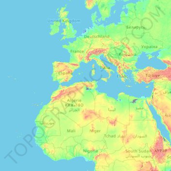
Name: Netherlands topographic map, elevation, terrain.
Location: Netherlands (11.82500 -68.62553 53.74440 7.22750)
Average elevation: 251 m
Minimum elevation: -72 m
Maximum elevation: 5,016 m
Netherlands literally means "lower countries" in reference to its low elevation and flat topography, with nearly 26% falling below sea level. Most of the areas below sea level, known as polders, are the result of land reclamation that began in the 14th century. In the Republican period, which began in 1588, the Netherlands entered a unique era of political, economic, and cultural greatness, ranked among the most powerful and influential in Europe and the world; this period is known as the Dutch Golden Age. During this time, its trading companies, the Dutch East India Company and the Dutch West India Company, established colonies and trading posts all over the world.
Other topographic maps
Click on a map to view its topography, its elevation and its terrain.
Barcelona
Spain > Catalonia > Barcelonès
Barcelona, Barcelonès, Barcelona, Catalonia, 08001, Spain
Average elevation: 65 m
Qatar
Qatar
Average elevation: 20 m
Central Ethiopia Regional State
Central Ethiopia Regional State, Ethiopia
Average elevation: 1,975 m
Morrocoy
Venezuela > Falcon State > Municipio Silva
Morrocoy, Parroquia Tucacas, Municipio Silva, Falcon State, Venezuela
Average elevation: 52 m
Redwood City
United States > California > San Mateo County
Redwood City, San Mateo County, California, United States
Average elevation: 32 m
Saudi Arabia
Saudi Arabia
Average elevation: 551 m
Cayo Sal
Venezuela > Federal Dependencies
Cayo Sal, Archipiélago Los Roques, Federal Dependencies, Venezuela
Average elevation: 0 m
Marondera
Zimbabwe > Mashonaland East Province > Marondera
Marondera, Mashonaland East Province, Zimbabwe
Average elevation: 1,637 m
Xã Phú Vang
Vietnam > Bến Tre Province > Bình Đại District
Xã Phú Vang, Bình Đại District, Bến Tre Province, Vietnam
Average elevation: 2 m
Algiers
United States > Louisiana > Orleans Parish > New Orleans
Algiers, New Orleans, Orleans Parish, Louisiana, 70114, United States
Average elevation: 2 m
South Pascagoula
United States > Mississippi > Jackson County > Pascagoula
South Pascagoula, Pascagoula, Jackson County, Mississippi, 39567, United States
Average elevation: 3 m
Grand Canyon
United States > Arizona > Coconino County
Grand Canyon, Coconino County, Arizona, United States
Average elevation: 1,021 m
Colorado Springs
United States > Colorado > El Paso County
Colorado Springs, El Paso County, Colorado, United States
Average elevation: 2,252 m
Wagga Wagga City Council
Wagga Wagga City Council, New South Wales, Australia
Average elevation: 282 m
Qasimabad
Pakistan > Sindh > Hyderabad District > حیدرآباد
Qasimabad, حیدرآباد, Qasimabad Taluka, Hyderabad District, Sindh, 91000, Pakistan
Average elevation: 21 m
Wilstone Reservoir
United Kingdom > England > Hertfordshire > Dacorum > Wilstone
Wilstone Reservoir, Tring Rural, Wilstone, Dacorum, Hertfordshire, England, United Kingdom
Average elevation: 110 m
Nigeria
Nigeria
Average elevation: 347 m
Bundook
Bundook, Mid-Coast Council, New South Wales, 2422, Australia
Average elevation: 152 m
Nanyuki
Kenya > Laikipia County > Laikipia East
Nanyuki, Laikipia East, Laikipia County, Rift Valley, Kenya
Average elevation: 1,937 m
San Miguel
San Miguel, Bulacan, Central Luzon, 3011, Philippines
Average elevation: 22 m
Elphinstone Point
United Kingdom > England > Medway
Elphinstone Point, Stoke, Medway, England, ME3 0HA, United Kingdom
Average elevation: 1 m
Shire Of Serpentine-Jarrahdale
Shire Of Serpentine-Jarrahdale, Western Australia, Australia
Average elevation: 177 m
Villabé
France > Ile-de-France > Essonne
Villabé, Évry, Essonne, Ile-de-France, Metropolitan France, 91100, France
Average elevation: 64 m
Southern Nations, Nationalities, and Peoples
Southern Nations, Nationalities, and Peoples, Ethiopia
Average elevation: 1,621 m
Middle East
United States > Maryland > Baltimore
Middle East, Baltimore, Maryland, United States
Average elevation: 29 m
Brasília
Brazil > Federal District > Região Integrada de Desenvolvimento do Distrito Federal e Entorno
Brasília, Plano Piloto, Região Geográfica Imediata do Distrito Federal, Região Integrada de Desenvolvimento do Distrito Federal e Entorno, Região Geográfica Intermediária do Distrito Federal, Federal District, Central-West Region, 70701-000, Brazil
Average elevation: 1,084 m
Descartes
France > Centre-Val de Loire > Indre-et-Loire
Descartes, Loches, Indre-et-Loire, Centre-Val de Loire, Metropolitan France, 37160, France
Average elevation: 90 m
Redcar
United Kingdom > England > North Yorkshire
Redcar, North Yorkshire, Tees Valley, England, TS10 1DZ, United Kingdom
Average elevation: 8 m
Saint-Paul-Mont-Penit
France > Pays de la Loire > Vendée
Saint-Paul-Mont-Penit, La Roche-sur-Yon, Vendée, Pays de la Loire, Metropolitan France, 85670, France
Average elevation: 46 m
Mondron
France > Brittany > Ille-et-Vilaine > Vergéal
Mondron, Vergéal, Fougères-Vitré, Ille-et-Vilaine, Brittany, Metropolitan France, 35680, France
Average elevation: 97 m
Ganbella
Spain > Pirinioaurrea / Prepirineo > Unciti
Ganbella, Unciti, Pirinioaurrea / Prepirineo, Spain
Average elevation: 948 m
Hyderabad
India > Telangana > Bahadurpura mandal
Hyderabad, Bahadurpura mandal, Hyderabad District, Telangana, India
Average elevation: 549 m
Elphinstone Point
India > Maharashtra > Mahabaleshwar > Dare
Elphinstone Point, Dare-NisanachiWaat, Dare, Mahabaleshwar, Satara, Maharashtra, India
Average elevation: 888 m
Cortegana
Spain > Andalusia > Sierra de Huelva
Cortegana, Sierra de Huelva, Huelva, Andalusia, 21330, Spain
Average elevation: 445 m