
San Sebastián topographic map
Interactive map
Click on the map to display elevation.
About this map
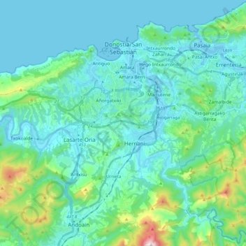
Name: San Sebastián topographic map, elevation, terrain.
Average elevation: 120 m
Minimum elevation: -2 m
Maximum elevation: 803 m
Other topographic maps
Click on a map to view its topography, its elevation and its terrain.
Vitoria-Gasteiz
Spain > Autonomous Community of the Basque Country > Gasteizko kuadrilla/Cuadrilla de Vitoria
Vitoria-Gasteiz, Gasteizko kuadrilla/Cuadrilla de Vitoria, Álava, Autonomous Community of the Basque Country, Spain
Average elevation: 626 m