
Vietnam topographic map
Interactive map
Click on the map to display elevation.
About this map
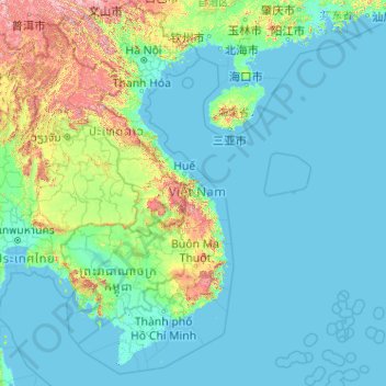
Name: Vietnam topographic map, elevation, terrain.
Location: Vietnam (7.69209 102.14386 23.39269 114.85726)
Average elevation: 173 m
Minimum elevation: -3 m
Maximum elevation: 2,808 m
Due to differences in latitude and the marked variety in topographical relief, Vietnam's climate tends to vary considerably for each region. Vietnam is a country located in the tropics, however Northern Vietnam, including Hanoi, is considered a subtropical region by Köppen climate classification and has times to be influenced by cold waves from the Northeast. Cold waves also can influence northern part of Central Vietnam. During the winter or dry season, extending roughly from November to April, the monsoon winds usually blow from the northeast along the Chinese coast and across the Gulf of Tonkin, picking up considerable moisture. The average annual temperature is generally higher in the plains than in the mountains, especially in southern Vietnam compared to the north. Temperatures vary less in the southern plains around Ho Chi Minh City and the Mekong Delta, ranging from between 21 and 35 °C (69.8 and 95.0 °F) over the year. In Hanoi and the surrounding areas of Red River Delta, the temperatures are much lower between 15 and 33 °C (59.0 and 91.4 °F). Seasonal variations in the mountains, plateaus, and the northernmost areas are much more dramatic, with temperatures varying from 3 °C (37.4 °F) in December and January to 37 °C (98.6 °F) in July and August. During winter, snow occasionally falls over the highest peaks of the far northern mountains near the Chinese border. Vietnam receives high rates of precipitation in the form of rainfall with an average amount from 1,500 mm (59 in) to 2,000 mm (79 in) during the monsoon seasons; this often causes flooding, especially in the cities with poor drainage systems. The country is also affected by tropical depressions, tropical storms and typhoons. Vietnam is one of the most vulnerable countries to climate change, with 55% of its population living in low-elevation coastal areas.
Other topographic maps
Click on a map to view its topography, its elevation and its terrain.
Barcelona
Spain > Catalonia > Barcelonès
Barcelona, Barcelonès, Barcelona, Catalonia, 08001, Spain
Average elevation: 65 m
Morrocoy
Venezuela > Falcon State > Municipio Silva
Morrocoy, Parroquia Tucacas, Municipio Silva, Falcon State, Venezuela
Average elevation: 52 m
Qatar
Qatar
Average elevation: 20 m
Saudi Arabia
Saudi Arabia
Average elevation: 551 m
Cayo Sal
Venezuela > Federal Dependencies
Cayo Sal, Archipiélago Los Roques, Federal Dependencies, Venezuela
Average elevation: 0 m
Coffs Harbour
Australia > New South Wales > Coffs Harbour
Coffs Harbour, Coffs Harbour City Council, New South Wales, 2450, Australia
Average elevation: 32 m
Krasnystaw
Poland > Lublin Voivodeship > Krasnystaw County
Krasnystaw, Krasnystaw County, Lublin Voivodeship, 22-300, Poland
Average elevation: 201 m
Marondera
Zimbabwe > Mashonaland East Province > Marondera
Marondera, Mashonaland East Province, Zimbabwe
Average elevation: 1,637 m
Algiers
United States > Louisiana > Orleans Parish > New Orleans
Algiers, New Orleans, Orleans Parish, Louisiana, 70114, United States
Average elevation: 2 m
Central Ethiopia Regional State
Central Ethiopia Regional State, Ethiopia
Average elevation: 1,975 m
Wagga Wagga City Council
Wagga Wagga City Council, New South Wales, Australia
Average elevation: 282 m
Redwood City
United States > California > San Mateo County
Redwood City, San Mateo County, California, United States
Average elevation: 32 m
Xã Phú Vang
Vietnam > Bến Tre Province > Bình Đại District
Xã Phú Vang, Bình Đại District, Bến Tre Province, Vietnam
Average elevation: 2 m
Grand Canyon
United States > Arizona > Coconino County
Grand Canyon, Coconino County, Arizona, United States
Average elevation: 1,021 m
Nigeria
Nigeria
Average elevation: 347 m
Colorado Springs
United States > Colorado > El Paso County
Colorado Springs, El Paso County, Colorado, United States
Average elevation: 2,252 m
South Pascagoula
United States > Mississippi > Jackson County > Pascagoula
South Pascagoula, Pascagoula, Jackson County, Mississippi, 39567, United States
Average elevation: 3 m
Qasimabad
Pakistan > Sindh > Hyderabad District > حیدرآباد
Qasimabad, حیدرآباد, Qasimabad Taluka, Hyderabad District, Sindh, 91000, Pakistan
Average elevation: 21 m
Wilstone Reservoir
United Kingdom > England > Hertfordshire > Dacorum > Wilstone
Wilstone Reservoir, Tring Rural, Wilstone, Dacorum, Hertfordshire, England, United Kingdom
Average elevation: 110 m
Villabé
France > Ile-de-France > Essonne
Villabé, Évry, Essonne, Ile-de-France, Metropolitan France, 91100, France
Average elevation: 64 m
Brasília
Brazil > Federal District > Região Integrada de Desenvolvimento do Distrito Federal e Entorno
Brasília, Plano Piloto, Região Geográfica Imediata do Distrito Federal, Região Integrada de Desenvolvimento do Distrito Federal e Entorno, Região Geográfica Intermediária do Distrito Federal, Federal District, Central-West Region, 70701-000, Brazil
Average elevation: 1,084 m
Elphinstone Point
India > Maharashtra > Mahabaleshwar > Dare
Elphinstone Point, Dare-NisanachiWaat, Dare, Mahabaleshwar, Satara, Maharashtra, India
Average elevation: 888 m
Ganbella
Spain > Pirinioaurrea / Prepirineo > Unciti
Ganbella, Unciti, Pirinioaurrea / Prepirineo, Spain
Average elevation: 948 m
Bundook
Bundook, Mid-Coast Council, New South Wales, 2422, Australia
Average elevation: 152 m
San Miguel
San Miguel, Bulacan, Central Luzon, 3011, Philippines
Average elevation: 22 m
Shire Of Serpentine-Jarrahdale
Shire Of Serpentine-Jarrahdale, Western Australia, Australia
Average elevation: 177 m
Southern Nations, Nationalities, and Peoples
Southern Nations, Nationalities, and Peoples, Ethiopia
Average elevation: 1,621 m
Nanyuki
Kenya > Laikipia County > Laikipia East
Nanyuki, Laikipia East, Laikipia County, Rift Valley, Kenya
Average elevation: 1,937 m
Elphinstone Point
United Kingdom > England > Medway
Elphinstone Point, Stoke, Medway, England, ME3 0HA, United Kingdom
Average elevation: 1 m
Cortegana
Spain > Andalusia > Sierra de Huelva
Cortegana, Sierra de Huelva, Huelva, Andalusia, 21330, Spain
Average elevation: 445 m
Descartes
France > Centre-Val de Loire > Indre-et-Loire
Descartes, Loches, Indre-et-Loire, Centre-Val de Loire, Metropolitan France, 37160, France
Average elevation: 90 m
Redcar
United Kingdom > England > North Yorkshire
Redcar, North Yorkshire, Tees Valley, England, TS10 1DZ, United Kingdom
Average elevation: 8 m
Middle East
United States > Maryland > Baltimore
Middle East, Baltimore, Maryland, United States
Average elevation: 29 m
Hyderabad
India > Telangana > Bahadurpura mandal
Hyderabad, Bahadurpura mandal, Hyderabad District, Telangana, India
Average elevation: 549 m
Saint-Paul-Mont-Penit
France > Pays de la Loire > Vendée
Saint-Paul-Mont-Penit, La Roche-sur-Yon, Vendée, Pays de la Loire, Metropolitan France, 85670, France
Average elevation: 46 m