
County Meath topographic map
Interactive map
Click on the map to display elevation.
About this map
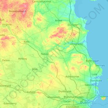
Name: County Meath topographic map, elevation, terrain.
Location: County Meath, Leinster, Ireland (53.38187 -7.34362 53.91754 -6.21291)
Average elevation: 64 m
Minimum elevation: -1 m
Maximum elevation: 323 m
Meath is largely flat and much of the county lies below 100 m (330 ft) above sea-level. The minor hills in the far west of the county at Loughcrew, and in the north at Carrickleck are the only upland areas of any significance. Slieve na Calliagh, at just 276 m (906 ft) in height, is the highest point in the county, making it the second lowest county top in Ireland. Carrickleck Hill, near the Cavan border, is the second highest peak in Meath, at 173 m (568 ft). The Hill of Tara is located south of Navan and, although just 155 m (509 ft) in height, is the most prominent feature in the local topography, commanding a panoramic view of the surrounding area.
Other topographic maps
Click on a map to view its topography, its elevation and its terrain.
The Municipal District of Fermoy
The Municipal District of Fermoy, County Cork, Munster, Ireland
Average elevation: 145 m
Sligo Municipal Borough District
Sligo Municipal Borough District, County Sligo, Connacht, Ireland
Average elevation: 87 m
Killarney
Killarney, Killarney Municipal District, County Kerry, Munster, Ireland
Average elevation: 57 m
Dún Laoghaire-Rathdown
Dún Laoghaire-Rathdown, County Dublin, Leinster, Ireland
Average elevation: 139 m
The Borough District of Wexford
The Borough District of Wexford, County Wexford, Leinster, Ireland
Average elevation: 29 m
Lucan
Ireland > County Dublin > Lucan
Lucan, South Dublin, County Dublin, Leinster, K78 K8F7, Ireland
Average elevation: 59 m
Rush Martello Tower
Rush Martello Tower, Tower Street, Rush, Rush ED, Rush, Fingal, County Dublin, Leinster, K56 ED95, Ireland
Average elevation: 2 m
North Constituency
North Constituency, Dublin, Dublin 1, Leinster, Ireland
Average elevation: 32 m
Dún Laoghaire
Dún Laoghaire, Dún Laoghaire-Rathdown, County Dublin, Leinster, A96 A258, Ireland
Average elevation: 21 m
Lugnaquilla
Lugnaquilla, The Municipal District of Baltinglass, County Wicklow, Leinster, Ireland
Average elevation: 697 m
Cherry Orchard
Cherry Orchard, Merchants Quay E ED, Dublin 8, Dublin, County Dublin, Leinster, Ireland
Average elevation: 25 m
Carrauntoohil
Carrauntoohil, Kenmare Municipal District, County Kerry, Munster, Ireland
Average elevation: 644 m
Rathfarnham Village ED
Rathfarnham Village ED, Rathfarnham, South Dublin, County Dublin, Leinster, DUBLIN 6W, Ireland
Average elevation: 55 m
Wicklow Mountains National Park
Wicklow Mountains National Park, Mullaghcleevaun to Moanbane and Silsean, Glenbride, Lackan, The Municipal District of Baltinglass, County Wicklow, Leinster, Ireland
Average elevation: 324 m
North Bull Island
North Bull Island, Raheny St. Assam ED, Dublin 5, Dublin, County Dublin, Leinster, Ireland
Average elevation: 2 m