
Plage de Pampelonne topographic map
Interactive map
Click on the map to display elevation.
About this map
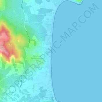
Name: Plage de Pampelonne topographic map, elevation, terrain.
Average elevation: 15 m
Minimum elevation: -1 m
Maximum elevation: 130 m
Other topographic maps
Click on a map to view its topography, its elevation and its terrain.
L'Escalet
France > Provence-Alpes-Côte d'Azur > Var > Ramatuelle
L'Escalet, Ramatuelle, Draguignan, Var, Provence-Alpes-Côte d'Azur, France métropolitaine, 83350, France
Average elevation: 38 m
Paillas
France > Provence-Alpes-Côte d'Azur > Var > Ramatuelle
Paillas, Ramatuelle, Draguignan, Var, Provence-Alpes-Côte d'Azur, France métropolitaine, 83350, France
Average elevation: 109 m
La Grangue
France > Provence-Alpes-Côte d'Azur > Var > Ramatuelle
La Grangue, Ramatuelle, Draguignan, Var, Provence-Alpes-Côte d'Azur, France métropolitaine, 83350, France
Average elevation: 33 m
Phare du Cap Camarat
France > Provence-Alpes-Côte d'Azur > Var > Ramatuelle
Phare du Cap Camarat, Sentier Littoral, Ramatuelle, Draguignan, Var, Provence-Alpes-Côte d'Azur, France métropolitaine, 83350, France
Average elevation: 18 m