
Grisons topographic map
Interactive map
Click on the map to display elevation.
About this map
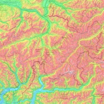
Name: Grisons topographic map, elevation, terrain.
Location: Grisons, Switzerland (46.16918 8.65106 47.06515 10.49229)
Average elevation: 1,737 m
Minimum elevation: 189 m
Maximum elevation: 4,001 m
The Grisons lies fully within the Alps, with elevations above sea-level ranging from 260 to 4,049 metres (853 to 13,284 ft). It is both one of the highest and lowest cantons, and the second-highest when considering mean elevation. As a consequence, its topography is extremely rugged and many of the highest settlements in the country (and Europe) are found there, notably in the Upper Engadin. The mountains are numerous; well over 1,000 summits are in the canton. The highest is Piz Bernina, closely followed by numerous peaks in the homonymous range. Other prominent mountains are Piz Russein, Piz Kesch, Calanda, Aroser Rothorn and Rheinwaldhorn, see list of mountains of Graubünden for a more exhaustive list. The canton includes numerous subranges of the Alps other than the Bernina. These are the Albula, the Bregaglia, the Glarus, the Gotthard, the Lepontine, the Livigno, the Plessur, the Oberhalbstein, the Ortler, the Rätikon, the Samnaun, the Sesvenna and the Silvretta ranges.
Other topographic maps
Click on a map to view its topography, its elevation and its terrain.
Nendaz
Switzerland > Wallis > Conthey
Nendaz, Conthey, Wallis, 1997, Switzerland
Average elevation: 1,771 m
Saas-Fee
Switzerland > Wallis > Visp
Saas-Fee, Visp, Wallis, 3906, Switzerland
Average elevation: 2,673 m
Crans-Montana
Switzerland > Wallis > Sierre
Crans-Montana, Sierre, Wallis, 3960, Switzerland
Average elevation: 1,660 m
Kiental
Switzerland > Bern > Frutigen-Niedersimmental administrative district > Reichenbach im Kandertal
Kiental, Reichenbach im Kandertal, Frutigen-Niedersimmental administrative district, Oberland administrative region, Bern, 3723, Switzerland
Average elevation: 1,363 m
Schloss Wittigkofen
Switzerland > Bern > Bern-Mittelland administrative district > Bern > Schloss Wittigkofen
Schloss Wittigkofen, Wittigkofenweg, Wittigkofen, Murifeld, Schloss Wittigkofen, Stadtteil IV, Bern, Bern-Mittelland administrative district, Bernese Mittelland administrative region, Bern, 3006, Switzerland
Average elevation: 568 m
Lausanne
Switzerland > Vaud > District de Lausanne
Lausanne, District de Lausanne, Vaud, Switzerland
Average elevation: 621 m
Zermatt
Switzerland > Wallis > Visp
Zermatt, Visp, Wallis, 3920, Switzerland
Average elevation: 2,921 m
Zernez
Switzerland > Grisons > Zernez
Zernez, Region Engiadina Bassa/Val Müstair, Grisons, 7530, Switzerland
Average elevation: 2,297 m
Zurich
Switzerland > Zurich > District Zurich
Zurich, District Zurich, Zurich, Switzerland
Average elevation: 499 m
Salvan
Switzerland > Valais/Wallis > Salvan
Salvan, Saint-Maurice, Valais/Wallis, Switzerland
Average elevation: 1,350 m
Andermatt
Switzerland > Uri > Andermatt
Andermatt, Korporation Ursern, Uri, 6490, Switzerland
Average elevation: 2,127 m
Saint-Gingolph
Switzerland > Valais/Wallis > Saint-Gingolph
Saint-Gingolph, Monthey, Valais/Wallis, 1898, Switzerland
Average elevation: 1,171 m
Renges
Switzerland > Vaud > Ecublens > Renges
Renges, Ecublens, District de l'Ouest lausannois, Vaud, 1024, Switzerland
Average elevation: 402 m
Hinterrhein
Hinterrhein, Viamala, Grisons, 7435, Switzerland
Average elevation: 1,781 m
Wald (ZH)
Switzerland > Zurich > Wald (ZH)
Wald (ZH), Bezirk Hinwil, Zurich, Switzerland
Average elevation: 798 m
Wünnewil-Flamatt
Switzerland > Fribourg > Wünnewil-Flamatt
Wünnewil-Flamatt, Sensebezirk, Fribourg, Switzerland
Average elevation: 622 m
Disentis/Mustér
Switzerland > Grisons > Disentis/Mustér
Disentis/Mustér, Surselva, Grisons, 7180, Switzerland
Average elevation: 2,068 m
Martigny
Switzerland > Valais/Wallis > Martigny
Martigny, Valais/Wallis, Switzerland
Average elevation: 829 m
La Heutte
Switzerland > Bern > La Heutte
La Heutte, Arrondissement administratif du Jura bernois, Bern, 2604, Switzerland
Average elevation: 892 m
Glarus Süd
Switzerland > Glarus > Glarus Süd
Glarus Süd, Glarus, Switzerland
Average elevation: 1,835 m
Montreux
Switzerland > Vaud > Montreux
Montreux, District de la Riviera-Pays-d’Enhaut, Vaud, Switzerland
Average elevation: 820 m
Lenk
Switzerland > Bern > Lenk
Lenk, Verwaltungskreis Obersimmental-Saanen, Verwaltungsregion Oberland, Bern, 3775, Switzerland
Average elevation: 1,931 m
Islas
Switzerland > Grisons > Zuoz
Islas, Zuoz, Maloja, Grisons, 7524, Switzerland
Average elevation: 1,812 m
Sous-les-Perrolets
Switzerland > Neuchâtel > Neuchâtel
Sous-les-Perrolets, Sous les perrolets, Pré Louiset, Neuchâtel, District de Neuchâtel, Neuchâtel, 2000, Switzerland
Average elevation: 603 m
La Riondaz
Switzerland > Vaud > Leysin
La Riondaz, Leysin, District d'Aigle, Vaud, 1854, Switzerland
Average elevation: 1,562 m
Rolle
Switzerland > Vaud > Rolle
Rolle, District de Nyon, Vaud, 1180, Switzerland
Average elevation: 394 m
Charmey
Switzerland > Fribourg > Val-de-Charmey
Charmey, Val-de-Charmey, Gruyère District, Fribourg, 1637, Switzerland
Average elevation: 1,299 m
Vaux
Switzerland > Vaud > Vaux
Vaux, District de Morges, Vaud, 1126, Switzerland
Average elevation: 509 m
Collonge-Bellerive
Switzerland > Geneva > Collonge-Bellerive
Collonge-Bellerive, Geneva, Switzerland
Average elevation: 403 m
Strahlhorn
Switzerland > Valais/Wallis > Saas-Almagell
Strahlhorn, Saas-Almagell, Visp, Valais/Wallis, 3905, Switzerland
Average elevation: 3,581 m
Visp
Switzerland > Valais/Wallis > Visp
Visp, Valais/Wallis, 3930, Switzerland
Average elevation: 1,195 m
Säntis
Switzerland > Appenzell Innerrhoden > Schwende
Säntis, Schwende, Appenzell Innerrhoden, 9057, Switzerland
Average elevation: 1,938 m
Allalinhorn
Switzerland > Valais/Wallis > Saas-Fee
Allalinhorn, Saas-Fee, Visp, Valais/Wallis, 3906, Switzerland
Average elevation: 3,490 m
Pennine Alps
Switzerland > Valais/Wallis > Zermatt
Pennine Alps, Zermatt, Visp, Valais/Wallis, 3920, Switzerland
Average elevation: 3,842 m
Nyon
Switzerland > Vaud > District de Nyon > Nyon
Nyon, Grand Genève, District de Nyon, Vaud, 1260, Switzerland
Average elevation: 404 m
Theodulgletscher
Switzerland > Valais/Wallis > Zermatt
Theodulgletscher, Klein Matterhorn, Trockener Steg, Zermatt, Visp, Valais/Wallis, 3920, Switzerland
Average elevation: 3,228 m
Haut Glacier d'Arolla
Switzerland > Valais/Wallis > Evolène
Haut Glacier d'Arolla, Evolène, Hérens, Valais/Wallis, 1983, Switzerland
Average elevation: 3,068 m
Nesthorn
Switzerland > Valais/Wallis > Naters
Nesthorn, Naters, Brig, Valais/Wallis, Switzerland
Average elevation: 3,137 m
Wetterhorn
Switzerland > Bern > Grindelwald
Wetterhorn, Grindelwald, Verwaltungskreis Interlaken-Oberhasli, Verwaltungsregion Oberland, Bern, Switzerland
Average elevation: 2,864 m
Eiger
Switzerland > Bern > Lauterbrunnen
Eiger, Lauterbrunnen, Verwaltungskreis Interlaken-Oberhasli, Verwaltungsregion Oberland, Bern, 3801, Switzerland
Average elevation: 2,940 m