
Bitung topographic map
Interactive map
Click on the map to display elevation.
About this map
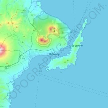
Name: Bitung topographic map, elevation, terrain.
Location: Bitung, North Sulawesi, 95522, Indonesia (1.28344 125.03408 1.60344 125.35408)
Average elevation: 115 m
Minimum elevation: -1 m
Maximum elevation: 1,762 m
Other topographic maps
Click on a map to view its topography, its elevation and its terrain.
Bangka Island
Indonesia > North Sulawesi > Bitung
Bangka Island, Bitung, North Sulawesi, Indonesia
Average elevation: 35 m