
Ajusco topographic map
Interactive map
Click on the map to display elevation.
About this map
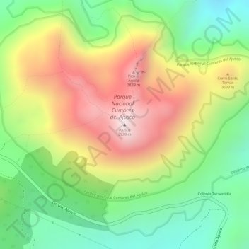
Name: Ajusco topographic map, elevation, terrain.
Location: Ajusco, Mexico City, 14715, Mexico (19.20723 -99.25814 19.20733 -99.25804)
Average elevation: 3,559 m
Minimum elevation: 3,227 m
Maximum elevation: 3,931 m
Other topographic maps
Click on a map to view its topography, its elevation and its terrain.
Parque España
Parque España, Condesa, Cuauhtémoc, Mexico City, 06140, Mexico
Average elevation: 2,242 m
Island of the Dead Dolls
Island of the Dead Dolls, Xochimilco, Mexico City, 16043, Mexico
Average elevation: 2,235 m
Bosque de Chapultepec
Bosque de Chapultepec, Mexico City, 11590, Mexico
Average elevation: 2,296 m