
Tuscola County topographic map
Interactive map
Click on the map to display elevation.
About this map
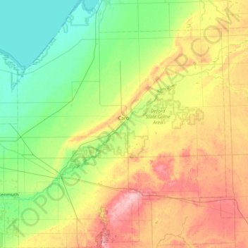
Name: Tuscola County topographic map, elevation, terrain.
Location: Tuscola County, Michigan, United States of America (43.22142 -83.69939 43.73415 -83.10384)
Average elevation: 217 m
Minimum elevation: 173 m
Maximum elevation: 297 m
Other topographic maps
Click on a map to view its topography, its elevation and its terrain.
Ferndale
United States of America > Michigan > Ferndale
Ferndale, Oakland County, Michigan, 48220, United States of America
Average elevation: 200 m
Genesee County
United States of America > Michigan
Genesee County, Michigan, United States of America
Average elevation: 246 m
Ingham County
United States of America > Michigan
Ingham County, Michigan, United States of America
Average elevation: 278 m
Ontonagon County
United States of America > Michigan
Ontonagon County, Michigan, United States of America
Average elevation: 334 m
East Lansing
United States of America > Michigan > East Lansing
East Lansing, Ingham County, Michigan, United States of America
Average elevation: 261 m
Cass City
United States of America > Michigan > Cass City
Cass City, Elkland Township, Tuscola County, Michigan, 48726, United States of America
Average elevation: 229 m
Baraga County
United States of America > Michigan
Baraga County, Michigan, United States of America
Average elevation: 378 m