
Kaohsiung topographic map
Interactive map
Click on the map to display elevation.
About this map
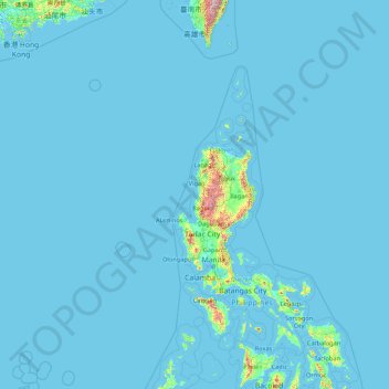
Name: Kaohsiung topographic map, elevation, terrain.
Location: Kaohsiung, Taiwan (10.34472 114.30722 23.47169 121.04904)
Average elevation: 29 m
Minimum elevation: -3 m
Maximum elevation: 3,381 m
Other topographic maps
Click on a map to view its topography, its elevation and its terrain.
Jungong Village
Taiwan > Hsinchu > East District
Jungong Village, East District, Hsinchu, Taiwan
Average elevation: 53 m
Sanxia District
Taiwan > New Taipei > Special-use Zone of National Taipei University
Sanxia District, Special-use Zone of National Taipei University, New Taipei, Taiwan
Average elevation: 349 m