
Macquarie topographic map
Interactive map
Click on the map to display elevation.
About this map
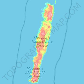
Name: Macquarie topographic map, elevation, terrain.
Location: Macquarie, Tasmania, Australia (-54.77699 158.77815 -54.48663 158.94701)
Average elevation: 20 m
Minimum elevation: 0 m
Maximum elevation: 395 m
Other topographic maps
Click on a map to view its topography, its elevation and its terrain.
Cape Naturaliste
Australia > Tasmania > Musselroe Bay
Cape Naturaliste, Forester Kangaroo Drive, Musselroe Bay, Tasmania, Australia
Average elevation: 2 m
Campbell Town
Australia > Tasmania > Campbell Town
Campbell Town, Tasmania, 7210, Australia
Average elevation: 214 m