
Middlesex County topographic map
Interactive map
Click on the map to display elevation.
About this map
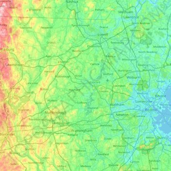
Name: Middlesex County topographic map, elevation, terrain.
Location: Middlesex County, Massachusetts, United States of America (42.15674 -71.89877 42.73659 -71.01978)
Average elevation: 80 m
Minimum elevation: -4 m
Maximum elevation: 391 m
Other topographic maps
Click on a map to view its topography, its elevation and its terrain.
Hampden County
United States of America > Massachusetts > West Springfield
Hampden County, Massachusetts, United States of America
Average elevation: 209 m
Ayer
United States of America > Massachusetts > Ayer > Ayer
Ayer, Middlesex County, Massachusetts, 01432, United States of America
Average elevation: 87 m
Berkshire County
United States of America > Massachusetts > Washington
Berkshire County, Massachusetts, United States of America
Average elevation: 359 m
Essex County
United States of America > Massachusetts
Essex County, Massachusetts, United States of America
Average elevation: 25 m