
Pershing County topographic map
Interactive map
Click on the map to display elevation.
About this map
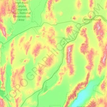
Name: Pershing County topographic map, elevation, terrain.
Location: Pershing County, Nevada, United States (39.99816 -119.33852 40.96106 -117.30002)
Average elevation: 1,449 m
Minimum elevation: 1,029 m
Maximum elevation: 2,962 m
According to the U.S. Census Bureau, the county has a total area of 6,067 square miles (15,710 km2), of which 6,037 square miles (15,640 km2) is land and 31 square miles (80 km2) (0.5%) is water. The tallest and most topographically prominent mountain in Pershing County is Star Peak at 9,840 ft (3,000 m).
Other topographic maps
Click on a map to view its topography, its elevation and its terrain.
Cherry Springs
United States > Nevada > Elko County
Cherry Springs, NV 20, Elko County, Nevada, 89822, United States
Average elevation: 2,062 m
Aurora Hill
Aurora Hill, Mineral County, Nevada, United States
Average elevation: 2,272 m
Esmeralda County
Esmeralda County, Nevada, United States
Average elevation: 1,789 m