
Taytay topographic map
Interactive map
Click on the map to display elevation.
About this map
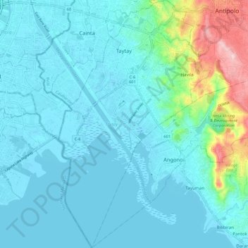
Name: Taytay topographic map, elevation, terrain.
Location: Taytay, Antipolo, Rizal, Calabarzon, 1870, Philippines (14.48945 121.10403 14.59150 121.16894)
Average elevation: 37 m
Minimum elevation: -3 m
Maximum elevation: 249 m
The shape of Taytay is rectangular – trapezoidal with gently hilly rolling terrain on its eastern side while relatively flat on its south-western side, including the poblacion. The municipality's highest elevation ranges from 200 to 255 meters which is situated along the inner north-eastern hills of Barangay Dolores, alongside the Antipolo Boundary. Its lowest points are from 5 to 20 meters along the southern portion of Barangay San Juan and Muzon towards Laguna Lake.