
Colchester topographic map
Interactive map
Click on the map to display elevation.
About this map
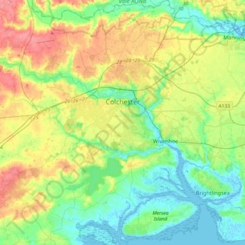
Name: Colchester topographic map, elevation, terrain.
Location: Colchester, Essex, England, United Kingdom (51.76571 0.69938 51.97715 1.02680)
Average elevation: 28 m
Minimum elevation: -2 m
Maximum elevation: 80 m
Other topographic maps
Click on a map to view its topography, its elevation and its terrain.
Hastingwood
United Kingdom > England > Essex > Epping Forest
Hastingwood, Epping Forest, Essex, England, CM17 9JX, United Kingdom
Average elevation: 87 m
Benfleet
United Kingdom > England > Essex > Castle Point
Benfleet, Castle Point, Essex, England, SS7 5SW, United Kingdom
Average elevation: 25 m