
Wallonia topographic map
Interactive map
Click on the map to display elevation.
About this map
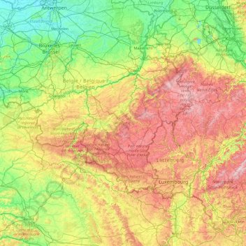
Name: Wallonia topographic map, elevation, terrain.
Location: Wallonia, Belgium (49.49698 2.84203 50.81212 6.40810)
Average elevation: 215 m
Minimum elevation: -2 m
Maximum elevation: 796 m
Wallonia is landlocked, with an area of 16,901 km2 (6,526 sq mi), or 55 percent of the total area of Belgium. The Sambre and Meuse valley, from Liège (70 m (230 ft)) to Charleroi (120 m (390 ft)) is an entrenched river in a fault line which separates Middle Belgium (elevation 100–200 m (330–660 ft)) and High Belgium (200–700 m (660–2,300 ft)). This fault line corresponds to a part of the southern coast of the late London-Brabant Massif. The valley, along with Haine and Vesdre valleys form the sillon industriel, the historical centre of the Belgian coalmining and steelmaking industry, and is also called the Walloon industrial backbone. Due to their long industrial historic record, several segments of the valley have received specific names: Borinage, around Mons, le Centre, around La Louvière, the Pays noir, around Charleroi and the Basse-Sambre, near Namur.
Other topographic maps
Click on a map to view its topography, its elevation and its terrain.
Auderghem - Oudergem
Auderghem - Oudergem, Brussels-Capital, 1160, Belgium
Average elevation: 91 m
Merchtem
Belgium > Flemish Brabant > Halle-Vilvoorde
Merchtem, Halle-Vilvoorde, Flemish Brabant, Flanders, 1785, Belgium
Average elevation: 36 m
Vitrival
Belgium > Namur > Namur > Fosses-la-Ville
Vitrival, Fosses-la-Ville, Namur, Wallonia, 5070, Belgium
Average elevation: 193 m
Montegnée
Belgium > Liège > Liège > Saint-Nicolas
Montegnée, Saint-Nicolas, Liège, Wallonia, 4420, Belgium
Average elevation: 158 m
Wetteren
Belgium > East Flanders > Dendermonde
Wetteren, Dendermonde, East Flanders, Flanders, 9230, Belgium
Average elevation: 14 m
Brussels
Belgium > Brussels-Capital > Brussels
Brussels, Brussels-Capital, Belgium
Average elevation: 54 m
Saint-Gilles - Sint-Gillis
Belgium > Brussels-Capital > Saint-Gilles - Sint-Gillis
Saint-Gilles - Sint-Gillis, Brussels-Capital, 1060, Belgium
Average elevation: 58 m
Quartier du Sablon - Zavelwijk
Belgium > Brussels-Capital > Ville de Bruxelles - Stad Brussel
Quartier du Sablon - Zavelwijk, Brussels, Ville de Bruxelles - Stad Brussel, Brussels-Capital, Belgium
Average elevation: 54 m
Watermael-Boitsfort - Watermaal-Bosvoorde
Belgium > Brussels-Capital > Watermael-Boitsfort - Watermaal-Bosvoorde
Watermael-Boitsfort - Watermaal-Bosvoorde, Brussels-Capital, 1170, Belgium
Average elevation: 100 m
Sint-Genesius-Rode
Belgium > Flanders > Sint-Genesius-Rode
Sint-Genesius-Rode, Halle-Vilvoorde, Flemish Brabant, Flanders, 1640, Belgium
Average elevation: 98 m