
Río Jequetepeque topographic map
Interactive map
Click on the map to display elevation.
About this map
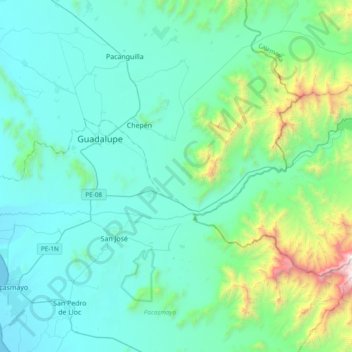
Name: Río Jequetepeque topographic map, elevation, terrain.
Location: Río Jequetepeque, San José, Pacasmayo, La Libertad, Perú (-7.33277 -79.58975 -7.23461 -79.20855)
Average elevation: 333 m
Minimum elevation: -1 m
Maximum elevation: 2,249 m
Other topographic maps
Click on a map to view its topography, its elevation and its terrain.
Pueblo Nuevo
Perú > La Libertad > San José
Pueblo Nuevo, San José, Pacasmayo, La Libertad, Perú
Average elevation: 136 m