
Arlington County topographic map
Interactive map
Click on the map to display elevation.
About this map
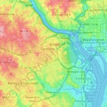
Name: Arlington County topographic map, elevation, terrain.
Location: Arlington County, Virginia, United States (38.82747 -77.17228 38.93435 -77.03100)
Average elevation: 54 m
Minimum elevation: -3 m
Maximum elevation: 139 m
Other topographic maps
Click on a map to view its topography, its elevation and its terrain.
Commonwealth Park
United States > Virginia > Culpeper County
Commonwealth Park, Culpeper County, Virginia, 22729, United States
Average elevation: 108 m
Prince George County
United States > Virginia > Prince George County
Prince George County, Virginia, United States
Average elevation: 29 m
Cascades
United States > Virginia > Loudoun County
Cascades, Loudoun County, Virginia, 20165, United States
Average elevation: 81 m